Kanganpur geodata
Kanganpur (Punjab) is a populated place; located in Pakistan in Asia/Karachi (GMT+5) time zone. With population of 21,788 people, there are 262 cities with bigger population in this country. Compared to other cities in Pakistan, 50.6% of cities are located further ↓South; 91.9% of cities are located further ←West and 53.7% of cities have lower elevation than Kanganpur. Note1


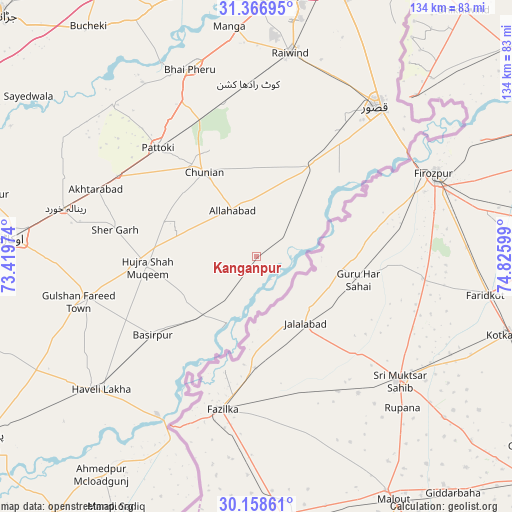
Kanganpur GPS coordinates[2]
30° 45' 52.848" North, 74° 7' 22.296" East
| Map corner | latitude | longitude |
|---|---|---|
| Upper-left | 31.36695°, | 73.41974° |
| Center: | 30.76468°, | 74.12286° |
| Lower-right: | 30.15861°, | 74.82599° |
| Map W x H: | 134.4×134.4 km | = 83.5×83.5mi |
| max Lat: | 36.32162° ⇑49.4% North |
| Kanganpur: | 30.76468° |
| min Lat: | ⇓50.6% South 24.14422° |
| min Long | Kanganpur | max Long |
| 61.74573° | 74.12286° | 75.63372° |
| W 91.9%⇐ | ⇒8.1% E |
Elevation
Elevation of Kanganpur is 188 m = 617 ft, and this is 157 m = 515 ft below average elevation for this country.
| Max E: |
2732 m = 8963 ft | 46.3% |
| Avg. | 345 m = 1132 ft | |
| Kanganpur | 188 m = 617 ft | |
Min E: |
3 m = 10 ft | 53.7% |
See also: Pakistan elevation on elevation.city.
Geographical zone
Kanganpur is located in North temperate zone (between Tropic of Cancer and the Arctic Circle). Distance of this Northern Tropic circle is 814.8 km =506.3 mi to South.| Distance of | km | miles | from Kanganpur |
|---|---|---|---|
| North Pole | 6586.4 | 4092.6 | to North |
| Arctic Circle | 3980.5 | 2473.4 | to North |
| Tropic Cancer | 814.8 | 506.3 | to South |
| Equator | 3420.7 | 2125.5 | to South |


Nearby cities:
15 places around Kanganpur: (largest is in red/bold)
• Basirpur
34.2 km =21.3 mi,  232°
232°
• Chunian
26.3 km =16.3 mi,  328°
328°
• Dipalpur
46.1 km =28.6 mi,  256°
256°
• Haveli Lakha
53.9 km =33.5 mi, 229°
• Hujra Shah Muqim
28.7 km =17.8 mi, 264°
• Kahna Nau
71 km =44.1 mi,  19°
19°
• Kasur
50.2 km =31.2 mi,  38°
38°
• Kot Radha Kishan
45.2 km =28.1 mi,  357°
357°
• Mianke Mor
51.4 km =31.9 mi,  341°
341°
• Mustafābād
61.2 km =38 mi,  283°
283°
• Okara
64.3 km =40 mi,  274°
274°
• Pattoki
38.3 km =23.8 mi,  317°
317°
• Raiwind
54.6 km =33.9 mi,  9°
9°
• Raja Jang
52.3 km =32.5 mi, 13°
• Renala Khurd
51.6 km =32.1 mi, 284°
Sources, notices
• [Note1] Compared only with cities in Pakistan existing in our database
• [Src1] Map data: © OpenStreetMap contributors (CC-BY-SA)
• [Src2] Other city data from geonames.org with taken over terms of usage.
• [Src3] Geographical zone / Annual Mean Temperature by Robert A. Rohde @ Wikipedia
