Dera Ismail Khan geodata
Dera Ismail Khan (Khyber Pakhtunkhwa) is a seat of a second-order administrative division; located in Pakistan in Asia/Karachi (GMT+5) time zone. With population of 101,616 people, there are 65 cities with bigger population in this country. Compared to other cities in Pakistan, 63.2% of cities are located further ↓South; 56.4% of cities are located further →East and 50.6% of cities have higher elevation than Dera Ismail Khan. Note1


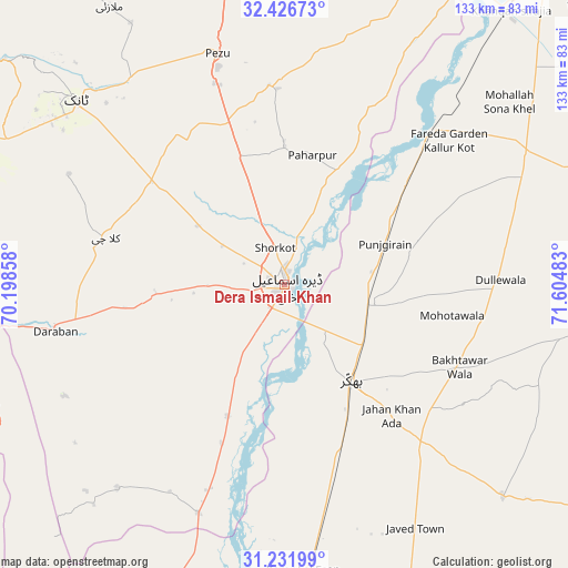
Dera Ismail Khan GPS coordinates[2]
31° 49' 52.644" North, 70° 54' 6.12" East
| Map corner | latitude | longitude |
|---|---|---|
| Upper-left | 32.42673°, | 70.19858° |
| Center: | 31.83129°, | 70.9017° |
| Lower-right: | 31.23199°, | 71.60483° |
| Map W x H: | 132.8×132.8 km | = 82.5×82.5mi |
| max Lat: | 36.32162° ⇑36.8% North |
| Dera Ismail Khan: | 31.83129° |
| min Lat: | ⇓63.2% South 24.14422° |
| min Long | Dera Ismail Kha | max Long |
| 61.74573° | 70.9017° | 75.63372° |
| W 43.6%⇐ | ⇒56.4% E |
Elevation
Elevation of Dera Ismail Khan is 177 m = 581 ft, and this is 168 m = 551 ft below average elevation for this country.
| Max E: |
2732 m = 8963 ft | 50.6% |
| Avg. | 345 m = 1132 ft | |
| Dera Ismail Khan | 177 m = 581 ft | |
Min E: |
3 m = 10 ft | 49.4% |
See also: Dera Ismail Khan elevation on elevation.city.
Geographical zone
Dera Ismail Khan is located in North temperate zone (between Tropic of Cancer and the Arctic Circle). Distance of this Northern Tropic circle is 933.4 km =580 mi to South.| Distance of | km | miles | from Dera Ismail Khan |
|---|---|---|---|
| North Pole | 6467.8 | 4018.9 | to North |
| Arctic Circle | 3861.9 | 2399.7 | to North |
| Tropic Cancer | 933.4 | 580 | to South |
| Equator | 3539.3 | 2199.2 | to South |


Nearby cities:
15 places around Dera Ismail Khan: (largest is in red/bold)
• Bhakkar
27.5 km =17.1 mi,  145°
145°
• Chak Two Hundred Forty-nine Thal Development Authority
78.1 km =48.5 mi,  158°
158°
• Darya Khan
19.6 km =12.2 mi,  105°
105°
• Dullewala
50.5 km =31.4 mi,  89°
89°
• Harnoli
79.1 km =49.2 mi,  51°
51°
• Kalur Kot
49.8 km =30.9 mi,  43°
43°
• Karor
67.6 km =42 mi,  175°
175°
• Kulachi
43.2 km =26.8 mi,  284°
284°
• Kundian
88.3 km =54.9 mi, 37°
• Lakki
86.3 km =53.6 mi,  0°
0°
• Layyah
96.8 km =60.1 mi, 177°
• Mankera
71 km =44.1 mi,  134°
134°
• Paharpur
31.1 km =19.3 mi,  12°
12°
• Shorkot
9.1 km =5.7 mi,  345°
345°
• Tank
65 km =40.4 mi,  311°
311°
Sources, notices
• [Note1] Compared only with cities in Pakistan existing in our database
• [Src1] Map data: © OpenStreetMap contributors (CC-BY-SA)
• [Src2] Other city data from geonames.org with taken over terms of usage.
• [Src3] Geographical zone / Annual Mean Temperature by Robert A. Rohde @ Wikipedia
