Kahuta geodata
Kahuta (Punjab) is a populated place; located in Pakistan in Asia/Karachi (GMT+5) time zone. With population of 22,551 people, there are 255 cities with bigger population in this country. Compared to other cities in Pakistan, 86.2% of cities are located further ↓South; 79.5% of cities are located further ←West and 84.2% of cities have lower elevation than Kahuta. Note1


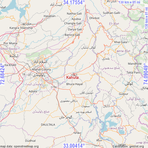
Kahuta GPS coordinates[2]
33° 35' 30.588" North, 73° 23' 14.496" East
| Map corner | latitude | longitude |
|---|---|---|
| Upper-left | 34.17554°, | 72.68424° |
| Center: | 33.59183°, | 73.38736° |
| Lower-right: | 33.00414°, | 74.09049° |
| Map W x H: | 130.2×130.2 km | = 80.9×80.9mi |
| max Lat: | 36.32162° ⇑13.8% North |
| Kahuta: | 33.59183° |
| min Lat: | ⇓86.2% South 24.14422° |
| min Long | Kahuta | max Long |
| 61.74573° | 73.38736° | 75.63372° |
| W 79.5%⇐ | ⇒20.5% E |
Elevation
Elevation of Kahuta is 610 m = 2001 ft, and this is 265 m = 869 ft above average elevation for this country.
| Max E: |
2732 m = 8963 ft | 15.8% |
| Kahuta | 610 m 2001 ft | |
| Avg. | 345 m = 1132 ft | |
Min E: |
3 m = 10 ft | 84.2% |
See also: Pakistan elevation on elevation.city.
Geographical zone
Kahuta is located in North temperate zone (between Tropic of Cancer and the Arctic Circle). Distance of this Northern Tropic circle is 1129.1 km =701.6 mi to South.| Distance of | km | miles | from Kahuta |
|---|---|---|---|
| North Pole | 6272 | 3897.2 | to North |
| Arctic Circle | 3666.1 | 2278 | to North |
| Tropic Cancer | 1129.1 | 701.6 | to South |
| Equator | 3735.1 | 2320.9 | to South |


Nearby cities:
15 places around Kahuta: (largest is in red/bold)
• Abbottabad
63.7 km =39.6 mi,  345°
345°
• Bagh
56.2 km =34.9 mi,  39°
39°
• Daultala
49.9 km =31 mi,  207°
207°
• Gujar Khan
38.3 km =23.8 mi,  191°
191°
• Haripur
61.5 km =38.2 mi,  317°
317°
• Havelian
55.5 km =34.5 mi,  337°
337°
• Islamabad
35 km =21.7 mi,  294°
294°
• Kamra
20.8 km =12.9 mi,  33°
33°
• Khalabat
69.4 km =43.1 mi, 318°
• Kotli
48.4 km =30.1 mi,  99°
99°
• Murree
35.2 km =21.9 mi,  0°
0°
• Nazir Town
33 km =20.5 mi,  164°
164°
• New Mirpur
59.9 km =37.2 mi,  145°
145°
• Rawala Kot
45.4 km =28.2 mi,  49°
49°
• Rawalpindi
31.4 km =19.5 mi,  271°
271°
Sources, notices
• [Note1] Compared only with cities in Pakistan existing in our database
• [Src1] Map data: © OpenStreetMap contributors (CC-BY-SA)
• [Src2] Other city data from geonames.org with taken over terms of usage.
• [Src3] Geographical zone / Annual Mean Temperature by Robert A. Rohde @ Wikipedia
