Rawalpindi geodata
Rawalpindi (Punjab) is a seat of a second-order administrative division; located in Pakistan in Asia/Karachi (GMT+5) time zone. With population of 1,743,101 people, there are 3 cities with bigger population in this country. Compared to other cities in Pakistan, 86.5% of cities are located further ↓South; 74.3% of cities are located further ←West and 81.9% of cities have lower elevation than Rawalpindi. Note1


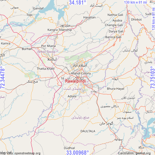
Rawalpindi GPS coordinates[2]
33° 35' 50.388" North, 73° 2' 52.44" East
| Map corner | latitude | longitude |
|---|---|---|
| Upper-left | 34.181°, | 72.34478° |
| Center: | 33.59733°, | 73.0479° |
| Lower-right: | 33.00968°, | 73.75103° |
| Map W x H: | 130.2×130.2 km | = 80.9×80.9mi |
| max Lat: | 36.32162° ⇑13.5% North |
| Rawalpindi: | 33.59733° |
| min Lat: | ⇓86.5% South 24.14422° |
| min Long | Rawalpindi | max Long |
| 61.74573° | 73.0479° | 75.63372° |
| W 74.3%⇐ | ⇒25.7% E |
Elevation
Elevation of Rawalpindi is 499 m = 1637 ft, and this is 154 m = 505 ft above average elevation for this country.
| Max E: |
2732 m = 8963 ft | 18.1% |
| Rawalpindi | 499 m 1637 ft | |
| Avg. | 345 m = 1132 ft | |
Min E: |
3 m = 10 ft | 81.9% |
See also: Rawalpindi elevation on elevation.city.
Geographical zone
Rawalpindi is located in North temperate zone (between Tropic of Cancer and the Arctic Circle). Distance of this Northern Tropic circle is 1129.8 km =702 mi to South.| Distance of | km | miles | from Rawalpindi |
|---|---|---|---|
| North Pole | 6271.4 | 3896.9 | to North |
| Arctic Circle | 3665.5 | 2277.6 | to North |
| Tropic Cancer | 1129.8 | 702 | to South |
| Equator | 3735.7 | 2321.3 | to South |


Nearby cities:
15 places around Rawalpindi: (largest is in red/bold)
• Abbottabad
62.9 km =39.1 mi,  13°
13°
• Amirabad
65.7 km =40.8 mi,  3°
3°
• Daultala
45.8 km =28.5 mi,  169°
169°
• Gujar Khan
45 km =28 mi,  148°
148°
• Haripur
45.7 km =28.4 mi,  346°
346°
• Havelian
51.8 km =32.2 mi, 11°
• Hazro City
62.1 km =38.6 mi,  304°
304°
• Islamabad
13.8 km =8.6 mi,  358°
358°
• Kahuta
31.4 km =19.5 mi,  91°
91°
• Kamra
46.1 km =28.6 mi,  68°
68°
• Khalabat
53.5 km =33.2 mi,  344°
344°
• Murree
46.9 km =29.1 mi,  42°
42°
• Nazir Town
51.8 km =32.2 mi,  128°
128°
• Sanjwal
59.7 km =37.1 mi,  287°
287°
• Topi
65.7 km =40.8 mi,  323°
323°
Sources, notices
• [Note1] Compared only with cities in Pakistan existing in our database
• [Src1] Map data: © OpenStreetMap contributors (CC-BY-SA)
• [Src2] Other city data from geonames.org with taken over terms of usage.
• [Src3] Geographical zone / Annual Mean Temperature by Robert A. Rohde @ Wikipedia
