Havelian geodata
Havelian (Khyber Pakhtunkhwa) is a populated place; located in Pakistan in Asia/Karachi (GMT+5) time zone. With population of 40,481 people, there are 154 cities with bigger population in this country. Compared to other cities in Pakistan, 90.5% of cities are located further ↓South; 76.1% of cities are located further ←West and 86.9% of cities have lower elevation than Havelian. Note1


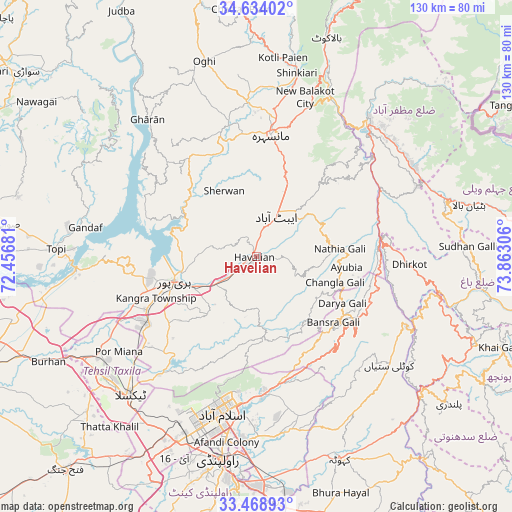
Havelian GPS coordinates[2]
34° 3' 12.528" North, 73° 9' 35.748" East
| Map corner | latitude | longitude |
|---|---|---|
| Upper-left | 34.63402°, | 72.45681° |
| Center: | 34.05348°, | 73.15993° |
| Lower-right: | 33.46893°, | 73.86306° |
| Map W x H: | 129.5×129.5 km | = 80.5×80.5mi |
| max Lat: | 36.32162° ⇑9.5% North |
| Havelian: | 34.05348° |
| min Lat: | ⇓90.5% South 24.14422° |
| min Long | Havelian | max Long |
| 61.74573° | 73.15993° | 75.63372° |
| W 76.1%⇐ | ⇒23.9% E |
Elevation
Elevation of Havelian is 863 m = 2831 ft, and this is 518 m = 1699 ft above average elevation for this country.
| Max E: |
2732 m = 8963 ft | 13.1% |
| Havelian | 863 m 2831 ft | |
| Avg. | 345 m = 1132 ft | |
Min E: |
3 m = 10 ft | 86.9% |
See also: Havelian elevation on elevation.city.
Geographical zone
Havelian is located in North temperate zone (between Tropic of Cancer and the Arctic Circle). Distance of this Northern Tropic circle is 1180.5 km =733.5 mi to South.| Distance of | km | miles | from Havelian |
|---|---|---|---|
| North Pole | 6220.7 | 3865.4 | to North |
| Arctic Circle | 3614.8 | 2246.1 | to North |
| Tropic Cancer | 1180.5 | 733.5 | to South |
| Equator | 3786.4 | 2352.8 | to South |


Nearby cities:
15 places around Havelian: (largest is in red/bold)
• Abbottabad
11.4 km =7.1 mi,  24°
24°
• Amirabad
16.2 km =10.1 mi,  336°
336°
• Baffa
43.1 km =26.8 mi,  7°
7°
• Bagh
57.4 km =35.7 mi,  98°
98°
• Haripur
21.6 km =13.4 mi,  253°
253°
• Hattian Bala
55.2 km =34.3 mi,  76°
76°
• Islamabad
38.5 km =23.9 mi,  196°
196°
• Kahuta
55.5 km =34.5 mi,  157°
157°
• Kamra
47.1 km =29.3 mi,  136°
136°
• Khalabat
24.9 km =15.5 mi,  271°
271°
• Mansehra
31 km =19.3 mi, 6°
• Murree
26.7 km =16.6 mi,  127°
127°
• Muzaffarābād
45.3 km =28.1 mi,  39°
39°
• Rawalpindi
51.8 km =32.2 mi,  191°
191°
• Topi
49.6 km =30.8 mi, 272°
Sources, notices
• [Note1] Compared only with cities in Pakistan existing in our database
• [Src1] Map data: © OpenStreetMap contributors (CC-BY-SA)
• [Src2] Other city data from geonames.org with taken over terms of usage.
• [Src3] Geographical zone / Annual Mean Temperature by Robert A. Rohde @ Wikipedia
