Bagh geodata
Bagh (Azad Kashmir) is a seat of a second-order administrative division; located in Pakistan in Asia/Karachi (GMT+5) time zone. In our database, there are 416 cities with bigger population. Compared to other cities in Pakistan, 88.7% of cities are located further ↓South; 86.2% of cities are located further ←West and 91% of cities have lower elevation than Bagh. Note1


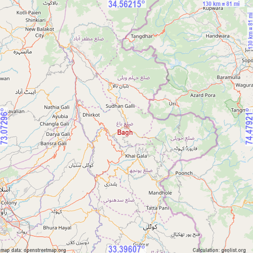
Bagh GPS coordinates[2]
33° 58' 51.996" North, 73° 46' 33.888" East
| Map corner | latitude | longitude |
|---|---|---|
| Upper-left | 34.56215°, | 73.07296° |
| Center: | 33.98111°, | 73.77608° |
| Lower-right: | 33.39607°, | 74.47921° |
| Map W x H: | 129.7×129.7 km | = 80.6×80.6mi |
| max Lat: | 36.32162° ⇑11.3% North |
| Bagh: | 33.98111° |
| min Lat: | ⇓88.7% South 24.14422° |
| min Long | Bagh | max Long |
| 61.74573° | 73.77608° | 75.63372° |
| W 86.2%⇐ | ⇒13.8% E |
Elevation
Elevation of Bagh is 1100 m = 3609 ft, and this is 755 m = 2477 ft above average elevation for this country.
| Max E: |
2732 m = 8963 ft | 9% |
| Bagh | 1100 m 3609 ft | |
| Avg. | 345 m = 1132 ft | |
Min E: |
3 m = 10 ft | 91% |
See also: Pakistan elevation on elevation.city.
Geographical zone
Bagh is located in North temperate zone (between Tropic of Cancer and the Arctic Circle). Distance of this Northern Tropic circle is 1172.4 km =728.5 mi to South.| Distance of | km | miles | from Bagh |
|---|---|---|---|
| North Pole | 6228.7 | 3870.3 | to North |
| Arctic Circle | 3622.8 | 2251.1 | to North |
| Tropic Cancer | 1172.4 | 728.5 | to South |
| Equator | 3778.3 | 2347.7 | to South |


Nearby cities:
15 places around Bagh: (largest is in red/bold)
• Abbottabad
55.1 km =34.2 mi,  289°
289°
• Amirabad
67.1 km =41.7 mi, 289°
• Athmuqam
66.6 km =41.4 mi,  9°
9°
• Baffa
71.8 km =44.6 mi,  314°
314°
• Haripur
77.6 km =48.2 mi,  271°
271°
• Hattian Bala
21.1 km =13.1 mi,  351°
351°
• Havelian
57.4 km =35.7 mi,  278°
278°
• Islamabad
73.6 km =45.7 mi,  246°
246°
• Kahuta
56.2 km =34.9 mi,  219°
219°
• Kamra
35.6 km =22.1 mi, 223°
• Kotli
52.8 km =32.8 mi,  167°
167°
• Mansehra
65.9 km =40.9 mi, 306°
• Murree
36.5 km =22.7 mi,  257°
257°
• Muzaffarābād
51.6 km =32.1 mi,  327°
327°
• Rawala Kot
13.8 km =8.6 mi,  186°
186°
Sources, notices
• [Note1] Compared only with cities in Pakistan existing in our database
• [Src1] Map data: © OpenStreetMap contributors (CC-BY-SA)
• [Src2] Other city data from geonames.org with taken over terms of usage.
• [Src3] Geographical zone / Annual Mean Temperature by Robert A. Rohde @ Wikipedia
