Murree geodata
Murree (Punjab) is a populated place; located in Pakistan in Asia/Karachi (GMT+5) time zone. With population of 25,247 people, there are 239 cities with bigger population in this country. Compared to other cities in Pakistan, 88.3% of cities are located further ↓South; 79.9% of cities are located further ←West and 98.4% of cities have lower elevation than Murree. Note1


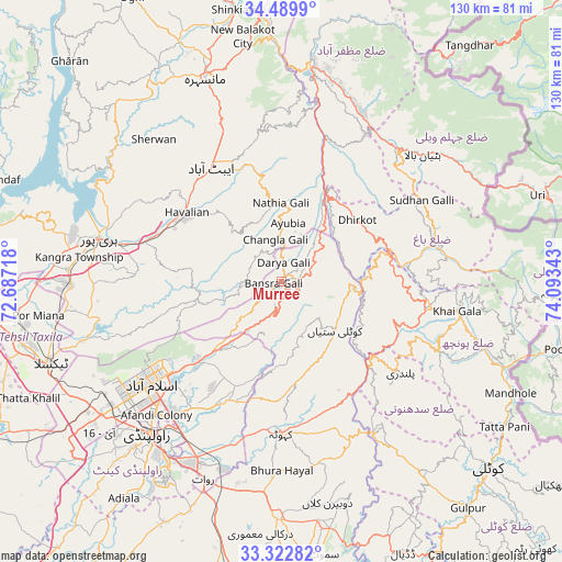
Murree GPS coordinates[2]
33° 54' 30.096" North, 73° 23' 25.08" East
| Map corner | latitude | longitude |
|---|---|---|
| Upper-left | 34.4899°, | 72.68718° |
| Center: | 33.90836°, | 73.3903° |
| Lower-right: | 33.32282°, | 74.09343° |
| Map W x H: | 129.8×129.8 km | = 80.7×80.7mi |
| max Lat: | 36.32162° ⇑11.7% North |
| Murree: | 33.90836° |
| min Lat: | ⇓88.3% South 24.14422° |
| min Long | Murree | max Long |
| 61.74573° | 73.3903° | 75.63372° |
| W 79.9%⇐ | ⇒20.1% E |
Elevation
Elevation of Murree is 2098 m = 6883 ft, and this is 1753 m = 5751 ft above average elevation for this country.
| Max E: |
2732 m = 8963 ft | 1.6% |
| Murree | 2098 m 6883 ft | |
| Avg. | 345 m = 1132 ft | |
Min E: |
3 m = 10 ft | 98.4% |
See also: Pakistan elevation on elevation.city.
Geographical zone
Murree is located in North temperate zone (between Tropic of Cancer and the Arctic Circle). Distance of this Northern Tropic circle is 1164.3 km =723.5 mi to South.| Distance of | km | miles | from Murree |
|---|---|---|---|
| North Pole | 6236.8 | 3875.4 | to North |
| Arctic Circle | 3630.9 | 2256.1 | to North |
| Tropic Cancer | 1164.3 | 723.5 | to South |
| Equator | 3770.3 | 2342.8 | to South |


Nearby cities:
15 places around Murree: (largest is in red/bold)
• Abbottabad
31.2 km =19.4 mi,  328°
328°
• Amirabad
41.5 km =25.8 mi,  318°
318°
• Baffa
60.8 km =37.8 mi,  345°
345°
• Bagh
36.5 km =22.7 mi,  77°
77°
• Haripur
43.2 km =26.8 mi,  283°
283°
• Hattian Bala
43.6 km =27.1 mi,  48°
48°
• Havelian
26.7 km =16.6 mi,  307°
307°
• Islamabad
38.2 km =23.7 mi,  237°
237°
• Kahuta
35.2 km =21.9 mi,  180°
180°
• Kamra
21.2 km =13.2 mi,  147°
147°
• Khalabat
49.1 km =30.5 mi,  290°
290°
• Mansehra
50.2 km =31.2 mi,  339°
339°
• Muzaffarābād
51.9 km =32.2 mi,  8°
8°
• Rawala Kot
34.6 km =21.5 mi,  99°
99°
• Rawalpindi
46.9 km =29.1 mi,  222°
222°
Sources, notices
• [Note1] Compared only with cities in Pakistan existing in our database
• [Src1] Map data: © OpenStreetMap contributors (CC-BY-SA)
• [Src2] Other city data from geonames.org with taken over terms of usage.
• [Src3] Geographical zone / Annual Mean Temperature by Robert A. Rohde @ Wikipedia
