Miro Khan geodata
Miro Khan (Sindh) is a populated place; located in Pakistan in Asia/Karachi (GMT+5) time zone. With population of 10,590 people, there are 349 cities with bigger population in this country. Compared to other cities in Pakistan, 75.6% of cities are located further ↑North; 86.5% of cities are located further →East and 78.8% of cities have higher elevation than Miro Khan. Note1


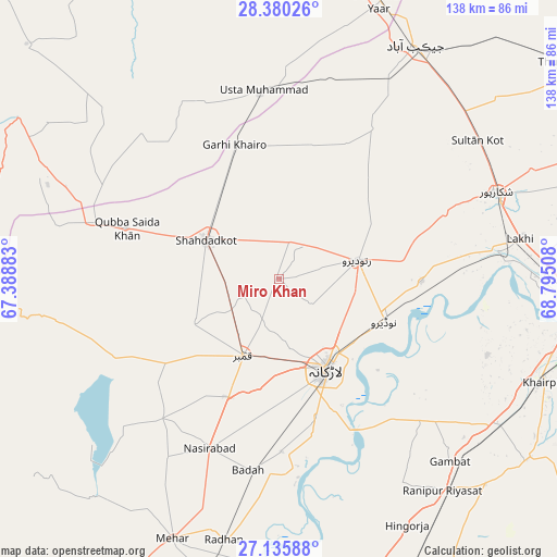
Miro Khan GPS coordinates[2]
27° 45' 35.46" North, 68° 5' 31.02" East
| Map corner | latitude | longitude |
|---|---|---|
| Upper-left | 28.38026°, | 67.38883° |
| Center: | 27.75985°, | 68.09195° |
| Lower-right: | 27.13588°, | 68.79508° |
| Map W x H: | 138.4×138.4 km | = 86×86mi |
| max Lat: | 36.32162° ⇑75.6% North |
| Miro Khan: | 27.75985° |
| min Lat: | ⇓24.4% South 24.14422° |
| min Long | Miro Khan | max Long |
| 61.74573° | 68.09195° | 75.63372° |
| W 13.5%⇐ | ⇒86.5% E |
Elevation
Elevation of Miro Khan is 55 m = 180 ft, and this is 290 m = 951 ft below average elevation for this country.
| Max E: |
2732 m = 8963 ft | 78.8% |
| Avg. | 345 m = 1132 ft | |
| Miro Khan | 55 m = 180 ft | |
Min E: |
3 m = 10 ft | 21.2% |
See also: Pakistan elevation on elevation.city.
Geographical zone
Miro Khan is located in North temperate zone (between Tropic of Cancer and the Arctic Circle). Distance of this Northern Tropic circle is 480.7 km =298.7 mi to South.| Distance of | km | miles | from Miro Khan |
|---|---|---|---|
| North Pole | 6920.5 | 4300.2 | to North |
| Arctic Circle | 4314.6 | 2681 | to North |
| Tropic Cancer | 480.7 | 298.7 | to South |
| Equator | 3086.6 | 1917.9 | to South |


Nearby cities:
15 places around Miro Khan: (largest is in red/bold)
• Chowki Jamali
33.4 km =20.8 mi,  329°
329°
• Dokri
42.9 km =26.7 mi,  179°
179°
• Garhi Khairo
35.2 km =21.9 mi,  341°
341°
• Garhiyasin
44.4 km =27.6 mi,  68°
68°
• Goth Garelo
36.1 km =22.4 mi, 182°
• Kambar
21.2 km =13.2 mi,  205°
205°
• Larkana
25.3 km =15.7 mi,  152°
152°
• Madeji
35.4 km =22 mi,  91°
91°
• Mehrabpur
39.2 km =24.4 mi,  350°
350°
• Nasirabad
45.5 km =28.3 mi,  202°
202°
• Naudero
28.4 km =17.6 mi,  111°
111°
• Ratodero
20 km =12.4 mi,  76°
76°
• Shahdad Kot
20.6 km =12.8 mi,  298°
298°
• Usta Muhammad
46.6 km =29 mi, 354°
• Warah
45.3 km =28.1 mi,  220°
220°
Sources, notices
• [Note1] Compared only with cities in Pakistan existing in our database
• [Src1] Map data: © OpenStreetMap contributors (CC-BY-SA)
• [Src2] Other city data from geonames.org with taken over terms of usage.
• [Src3] Geographical zone / Annual Mean Temperature by Robert A. Rohde @ Wikipedia
