Jhelum geodata
Jhelum (Punjab) is a seat of a second-order administrative division; located in Pakistan in Asia/Karachi (GMT+5) time zone. With population of 164,080 people, there are 40 cities with bigger population in this country. Compared to other cities in Pakistan, 82.2% of cities are located further ↓South; 84.9% of cities are located further ←West and 67% of cities have lower elevation than Jhelum. Note1


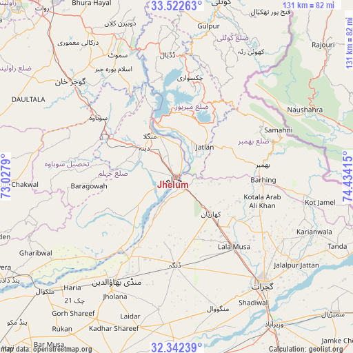
Jhelum GPS coordinates[2]
32° 56' 4.128" North, 73° 43' 51.672" East
| Map corner | latitude | longitude |
|---|---|---|
| Upper-left | 33.52263°, | 73.0279° |
| Center: | 32.93448°, | 73.73102° |
| Lower-right: | 32.34239°, | 74.43415° |
| Map W x H: | 131.2×131.2 km | = 81.5×81.5mi |
| max Lat: | 36.32162° ⇑17.8% North |
| Jhelum: | 32.93448° |
| min Lat: | ⇓82.2% South 24.14422° |
| min Long | Jhelum | max Long |
| 61.74573° | 73.73102° | 75.63372° |
| W 84.9%⇐ | ⇒15.1% E |
Elevation
Elevation of Jhelum is 230 m = 755 ft, and this is 115 m = 377 ft below average elevation for this country.
| Max E: |
2732 m = 8963 ft | 33% |
| Avg. | 345 m = 1132 ft | |
| Jhelum | 230 m = 755 ft | |
Min E: |
3 m = 10 ft | 67% |
See also: Jhelum elevation on elevation.city.
Geographical zone
Jhelum is located in North temperate zone (between Tropic of Cancer and the Arctic Circle). Distance of this Northern Tropic circle is 1056.1 km =656.2 mi to South.| Distance of | km | miles | from Jhelum |
|---|---|---|---|
| North Pole | 6345.1 | 3942.7 | to North |
| Arctic Circle | 3739.2 | 2323.4 | to North |
| Tropic Cancer | 1056.1 | 656.2 | to South |
| Equator | 3662 | 2275.5 | to South |


Nearby cities:
15 places around Jhelum: (largest is in red/bold)
• Bhimbar
32.7 km =20.3 mi,  82°
82°
• Daultala
62 km =38.5 mi,  297°
297°
• Dinga
32.6 km =20.3 mi,  181°
181°
• Gujar Khan
53.3 km =33.1 mi,  311°
311°
• Gujrat
51.4 km =31.9 mi,  141°
141°
• Jalalpur Jattan
55.1 km =34.2 mi,  126°
126°
• Kharian
19.6 km =12.2 mi, 132°
• Kunjah
50.4 km =31.3 mi,  153°
153°
• Lala Musa
33.5 km =20.8 mi, 140°
• Mandi Bahauddin
44.7 km =27.8 mi,  210°
210°
• Mehmand Chak
18.7 km =11.6 mi, 152°
• Nazir Town
47.3 km =29.4 mi,  330°
330°
• New Mirpur
23.8 km =14.8 mi,  4°
4°
• Phalia
57.8 km =35.9 mi,  194°
194°
• Sarai Alamgir
4 km =2.5 mi, 145°
In other languages:
- In German: Jhelam
- In Italian: Alessandria Bucefala
- In Russian: Джелам
- In Chinese: 傑赫勒姆
Sources, notices
• [Note1] Compared only with cities in Pakistan existing in our database
• [Src1] Map data: © OpenStreetMap contributors (CC-BY-SA)
• [Src2] Other city data from geonames.org with taken over terms of usage.
• [Src3] Geographical zone / Annual Mean Temperature by Robert A. Rohde @ Wikipedia
