Chak Thirty-one -Eleven Left geodata
Chak Thirty-one -Eleven Left (Punjab) is a populated place; located in Pakistan in Asia/Karachi (GMT+5) time zone. With population of 45,665 people, there are 142 cities with bigger population in this country. Compared to other cities in Pakistan, 54.9% of cities are located further ↑North; 68.2% of cities are located further ←West and 58.5% of cities have higher elevation than Chak Thirty-one -Eleven Left. Note1
Current local time in Chak Thirty-one -Eleven Left:
12:16 AM, SaturdayDifference from your time zone: hours


Chak Thirty-one -Eleven Left GPS coordinates[2]
30° 25' 25.968" North, 72° 41' 50.532" East
| Map corner | latitude | longitude |
|---|---|---|
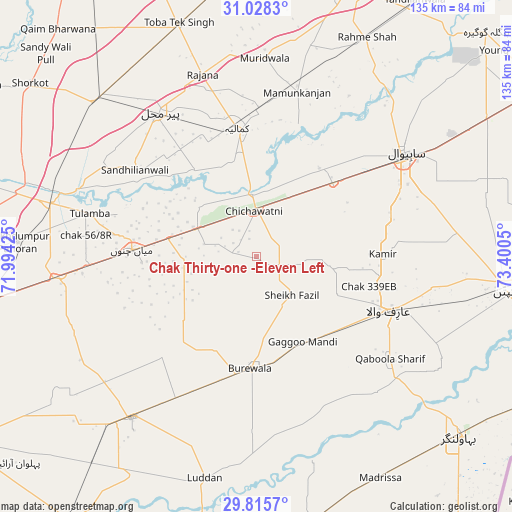
| Upper-left | 31.0283°, | 71.99425° |
| Center: | 30.42388°, | 72.69737° |
| Lower-right: | 29.8157°, | 73.4005° |
| Map W x H: | 134.8×134.8 km | = 83.8×83.8mi |
| max Lat: | 36.32162° ⇑54.9% North |
| Chak Thirty-one -Eleven Left: | 30.42388° |
| min Lat: | ⇓45.1% South 24.14422° |
| min Long | Chak Thirty-one | max Long |
| 61.74573° | 72.69737° | 75.63372° |
| W 68.2%⇐ | ⇒31.8% E |
Elevation
Elevation of Chak Thirty-one -Eleven Left is 154 m = 505 ft, and this is 191 m = 627 ft below average elevation for this country.
| Max E: |
2732 m = 8963 ft | 58.5% |
| Avg. | 345 m = 1132 ft | |
| Chak Thirty-one -Eleven Left | 154 m = 505 ft | |
Min E: |
3 m = 10 ft | 41.5% |
See also: Chak Thirty-one -Eleven Left elevation on elevation.city.
Geographical zone
Chak Thirty-one -Eleven Left is located in North temperate zone (between Tropic of Cancer and the Arctic Circle). Distance of this Northern Tropic circle is 776.9 km =482.7 mi to South.| Distance of | km | miles | from Chak Thirty-one -Eleven Left |
|---|---|---|---|
| North Pole | 6624.2 | 4116.1 | to North |
| Arctic Circle | 4018.4 | 2496.9 | to North |
| Tropic Cancer | 776.9 | 482.7 | to South |
| Equator | 3382.8 | 2102 | to South |


Nearby cities:
15 places around Chak Thirty-one -Eleven Left: (largest is in red/bold)
• Arifwala
38.3 km =23.8 mi,  112°
112°
• Bahawalnagar
67.9 km =42.2 mi,  78°
78°
• Būrewāla
29 km =18 mi,  189°
189°
• Chak Azam Sahu
48.3 km =30 mi,  40°
40°
• Chak One Hundred Twenty Nine Left
33.4 km =20.8 mi,  88°
88°
• Chichawatni
11.8 km =7.3 mi,  357°
357°
• Kamalia
34.1 km =21.2 mi,  351°
351°
• Mamu Kanjan
46.2 km =28.7 mi,  12°
12°
• Mian Channun
32.7 km =20.3 mi,  273°
273°
• Pakpattan
67 km =41.6 mi,  97°
97°
• Pir Mahal
45.7 km =28.4 mi,  326°
326°
• Sahiwal
47.2 km =29.3 mi,  55°
55°
• Talamba
45.2 km =28.1 mi,  284°
284°
• Toba Tek Singh
64.2 km =39.9 mi,  341°
341°
• Vihari
53.5 km =33.2 mi,  217°
217°
Sources, notices
• [Note1] Compared only with cities in Pakistan existing in our database
• [Src1] Map data: © OpenStreetMap contributors (CC-BY-SA)
• [Src2] Other city data from geonames.org with taken over terms of usage.
• [Src3] Geographical zone / Annual Mean Temperature by Robert A. Rohde @ Wikipedia
