Talamba geodata
Talamba (Punjab) is a populated place; located in Pakistan in Asia/Karachi (GMT+5) time zone. With population of 28,151 people, there are 219 cities with bigger population in this country. Compared to other cities in Pakistan, 53.5% of cities are located further ↑North; 59.4% of cities are located further ←West and 59.1% of cities have higher elevation than Talamba. Note1


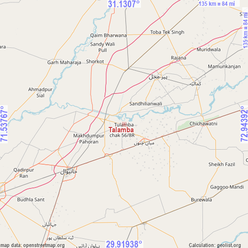
Talamba GPS coordinates[2]
30° 31' 36.948" North, 72° 14' 26.844" East
| Map corner | latitude | longitude |
|---|---|---|
| Upper-left | 31.1307°, | 71.53767° |
| Center: | 30.52693°, | 72.24079° |
| Lower-right: | 29.91938°, | 72.94392° |
| Map W x H: | 134.7×134.7 km | = 83.7×83.7mi |
| max Lat: | 36.32162° ⇑53.5% North |
| Talamba: | 30.52693° |
| min Lat: | ⇓46.5% South 24.14422° |
| min Long | Talamba | max Long |
| 61.74573° | 72.24079° | 75.63372° |
| W 59.4%⇐ | ⇒40.6% E |
Elevation
Elevation of Talamba is 149 m = 489 ft, and this is 196 m = 643 ft below average elevation for this country.
| Max E: |
2732 m = 8963 ft | 59.1% |
| Avg. | 345 m = 1132 ft | |
| Talamba | 149 m = 489 ft | |
Min E: |
3 m = 10 ft | 40.9% |
See also: Pakistan elevation on elevation.city.
Geographical zone
Talamba is located in North temperate zone (between Tropic of Cancer and the Arctic Circle). Distance of this Northern Tropic circle is 788.4 km =489.9 mi to South.| Distance of | km | miles | from Talamba |
|---|---|---|---|
| North Pole | 6612.8 | 4109 | to North |
| Arctic Circle | 4006.9 | 2489.8 | to North |
| Tropic Cancer | 788.4 | 489.9 | to South |
| Equator | 3394.3 | 2109.1 | to South |


Nearby cities:
15 places around Talamba: (largest is in red/bold)
• Ahmadpur Sial
50.5 km =31.4 mi,  289°
289°
• Būrewāla
56.1 km =34.9 mi,  135°
135°
• Chak Thirty-one -Eleven Left
45.2 km =28.1 mi,  104°
104°
• Chichawatni
43.2 km =26.8 mi,  89°
89°
• Garh Maharaja
46.9 km =29.1 mi,  316°
316°
• Kabirwala
38.7 km =24 mi,  249°
249°
• Kamalia
44.7 km =27.8 mi,  60°
60°
• Khanewal
38.8 km =24.1 mi,  229°
229°
• Mamu Kanjan
63.2 km =39.3 mi, 57°
• Mian Channun
14.7 km =9.1 mi,  130°
130°
• Pir Mahal
32.5 km =20.2 mi,  34°
34°
• Qadirpur Ran
60.5 km =37.6 mi,  244°
244°
• Sarai Sidhu
27 km =16.8 mi, 286°
• Toba Tek Singh
54.5 km =33.9 mi, 25°
• Vihari
54.8 km =34.1 mi,  168°
168°
Sources, notices
• [Note1] Compared only with cities in Pakistan existing in our database
• [Src1] Map data: © OpenStreetMap contributors (CC-BY-SA)
• [Src2] Other city data from geonames.org with taken over terms of usage.
• [Src3] Geographical zone / Annual Mean Temperature by Robert A. Rohde @ Wikipedia
