Khanewal geodata
Khanewal (Punjab) is a seat of a second-order administrative division; located in Pakistan in Asia/Karachi (GMT+5) time zone. In our database, there are 416 cities with bigger population. Compared to other cities in Pakistan, 56% of cities are located further ↑North; 56.2% of cities are located further ←West and 62.8% of cities have higher elevation than Khanewal. Note1


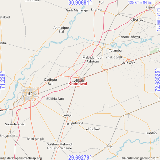
Khanewal GPS coordinates[2]
30° 18' 6.228" North, 71° 55' 55.632" East
| Map corner | latitude | longitude |
|---|---|---|
| Upper-left | 30.90691°, | 71.229° |
| Center: | 30.30173°, | 71.93212° |
| Lower-right: | 29.69279°, | 72.63525° |
| Map W x H: | 135×135 km | = 83.9×83.9mi |
| max Lat: | 36.32162° ⇑56% North |
| Khanewal: | 30.30173° |
| min Lat: | ⇓44% South 24.14422° |
| min Long | Khanewal | max Long |
| 61.74573° | 71.93212° | 75.63372° |
| W 56.2%⇐ | ⇒43.8% E |
Elevation
Elevation of Khanewal is 138 m = 453 ft, and this is 207 m = 679 ft below average elevation for this country.
| Max E: |
2732 m = 8963 ft | 62.8% |
| Avg. | 345 m = 1132 ft | |
| Khanewal | 138 m = 453 ft | |
Min E: |
3 m = 10 ft | 37.2% |
See also: Pakistan elevation on elevation.city.
Geographical zone
Khanewal is located in North temperate zone (between Tropic of Cancer and the Arctic Circle). Distance of this Northern Tropic circle is 763.3 km =474.3 mi to South.| Distance of | km | miles | from Khanewal |
|---|---|---|---|
| North Pole | 6637.8 | 4124.5 | to North |
| Arctic Circle | 4031.9 | 2505.3 | to North |
| Tropic Cancer | 763.3 | 474.3 | to South |
| Equator | 3369.2 | 2093.5 | to South |


Nearby cities:
15 places around Khanewal: (largest is in red/bold)
• Ahmadpur Sial
45.6 km =28.3 mi,  336°
336°
• Būrewāla
70.6 km =43.9 mi,  102°
102°
• Chak Thirty-one -Eleven Left
74.7 km =46.4 mi,  79°
79°
• Dunyapur
58.4 km =36.3 mi,  198°
198°
• Garh Maharaja
59.2 km =36.8 mi,  357°
357°
• Kabirwala
13.2 km =8.2 mi,  329°
329°
• Kahror Pakka
75.3 km =46.8 mi,  181°
181°
• Mailsi
60.3 km =37.5 mi,  157°
157°
• Mian Channun
43.6 km =27.1 mi,  69°
69°
• Multan
45.1 km =28 mi,  255°
255°
• Pir Mahal
70.6 km =43.9 mi,  42°
42°
• Qadirpur Ran
25 km =15.5 mi,  267°
267°
• Sarai Sidhu
32.8 km =20.4 mi,  6°
6°
• Talamba
38.8 km =24.1 mi,  49°
49°
• Vihari
49.8 km =30.9 mi,  125°
125°
Sources, notices
• [Note1] Compared only with cities in Pakistan existing in our database
• [Src1] Map data: © OpenStreetMap contributors (CC-BY-SA)
• [Src2] Other city data from geonames.org with taken over terms of usage.
• [Src3] Geographical zone / Annual Mean Temperature by Robert A. Rohde @ Wikipedia
