Kamalia geodata
Kamalia (Punjab) is a populated place; located in Pakistan in Asia/Karachi (GMT+5) time zone. With population of 112,426 people, there are 61 cities with bigger population in this country. Compared to other cities in Pakistan, 50.8% of cities are located further ↑North; 66.8% of cities are located further ←West and 56.7% of cities have higher elevation than Kamalia. Note1


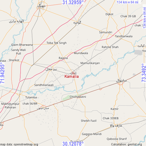
Kamalia GPS coordinates[2]
30° 43' 37.488" North, 72° 38' 45.852" East
| Map corner | latitude | longitude |
|---|---|---|
| Upper-left | 31.32959°, | 71.94295° |
| Center: | 30.72708°, | 72.64607° |
| Lower-right: | 30.12078°, | 73.3492° |
| Map W x H: | 134.4×134.4 km | = 83.5×83.5mi |
| max Lat: | 36.32162° ⇑50.8% North |
| Kamalia: | 30.72708° |
| min Lat: | ⇓49.2% South 24.14422° |
| min Long | Kamalia | max Long |
| 61.74573° | 72.64607° | 75.63372° |
| W 66.8%⇐ | ⇒33.2% E |
Elevation
Elevation of Kamalia is 160 m = 525 ft, and this is 185 m = 607 ft below average elevation for this country.
| Max E: |
2732 m = 8963 ft | 56.7% |
| Avg. | 345 m = 1132 ft | |
| Kamalia | 160 m = 525 ft | |
Min E: |
3 m = 10 ft | 43.3% |
See also: Kamalia elevation on elevation.city.
Geographical zone
Kamalia is located in North temperate zone (between Tropic of Cancer and the Arctic Circle). Distance of this Northern Tropic circle is 810.6 km =503.7 mi to South.| Distance of | km | miles | from Kamalia |
|---|---|---|---|
| North Pole | 6590.5 | 4095.1 | to North |
| Arctic Circle | 3984.6 | 2475.9 | to North |
| Tropic Cancer | 810.6 | 503.7 | to South |
| Equator | 3416.5 | 2122.9 | to South |


Nearby cities:
15 places around Kamalia: (largest is in red/bold)
• Arifwala
63 km =39.1 mi,  140°
140°
• Būrewāla
62.3 km =38.7 mi,  179°
179°
• Chak Azam Sahu
36.6 km =22.7 mi,  85°
85°
• Chak One Hundred Twenty Nine Left
50.6 km =31.4 mi,  130°
130°
• Chak Thirty-one -Eleven Left
34.1 km =21.2 mi,  171°
171°
• Chichawatni
22.3 km =13.9 mi, 168°
• Dijkot
63.9 km =39.7 mi,  31°
31°
• Gojra
47.1 km =29.3 mi,  4°
4°
• Mamu Kanjan
18.6 km =11.6 mi,  51°
51°
• Mian Channun
42.2 km =26.2 mi,  221°
221°
• Pir Mahal
20.7 km =12.9 mi,  282°
282°
• Sahiwal
44.1 km =27.4 mi,  98°
98°
• Talamba
44.7 km =27.8 mi,  240°
240°
• Tandlianwala
57.6 km =35.8 mi, 53°
• Toba Tek Singh
31.3 km =19.4 mi,  330°
330°
Sources, notices
• [Note1] Compared only with cities in Pakistan existing in our database
• [Src1] Map data: © OpenStreetMap contributors (CC-BY-SA)
• [Src2] Other city data from geonames.org with taken over terms of usage.
• [Src3] Geographical zone / Annual Mean Temperature by Robert A. Rohde @ Wikipedia
