Chichawatni geodata
Chichawatni (Punjab) is a populated place; located in Pakistan in Asia/Karachi (GMT+5) time zone. With population of 82,762 people, there are 79 cities with bigger population in this country. Compared to other cities in Pakistan, 53.3% of cities are located further ↑North; 67.9% of cities are located further ←West and 54.4% of cities have higher elevation than Chichawatni. Note1


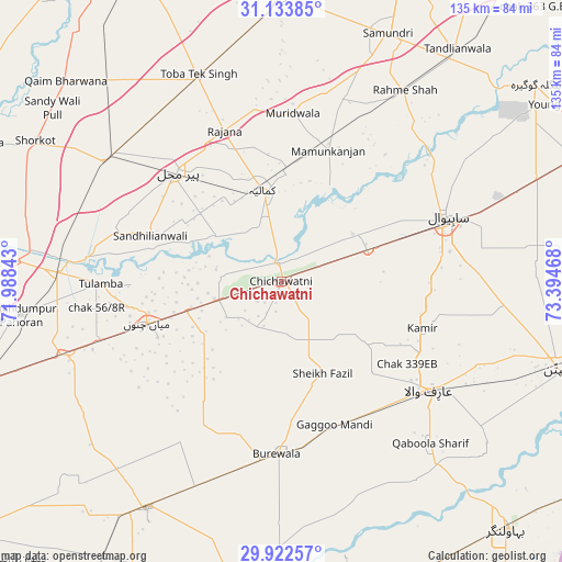
Chichawatni GPS coordinates[2]
30° 31' 48.36" North, 72° 41' 29.58" East
| Map corner | latitude | longitude |
|---|---|---|
| Upper-left | 31.13385°, | 71.98843° |
| Center: | 30.5301°, | 72.69155° |
| Lower-right: | 29.92257°, | 73.39468° |
| Map W x H: | 134.7×134.7 km | = 83.7×83.7mi |
| max Lat: | 36.32162° ⇑53.3% North |
| Chichawatni: | 30.5301° |
| min Lat: | ⇓46.7% South 24.14422° |
| min Long | Chichawatni | max Long |
| 61.74573° | 72.69155° | 75.63372° |
| W 67.9%⇐ | ⇒32.1% E |
Elevation
Elevation of Chichawatni is 165 m = 541 ft, and this is 180 m = 591 ft below average elevation for this country.
| Max E: |
2732 m = 8963 ft | 54.4% |
| Avg. | 345 m = 1132 ft | |
| Chichawatni | 165 m = 541 ft | |
Min E: |
3 m = 10 ft | 45.6% |
See also: Chichawatni elevation on elevation.city.
Geographical zone
Chichawatni is located in North temperate zone (between Tropic of Cancer and the Arctic Circle). Distance of this Northern Tropic circle is 788.7 km =490.1 mi to South.| Distance of | km | miles | from Chichawatni |
|---|---|---|---|
| North Pole | 6612.4 | 4108.8 | to North |
| Arctic Circle | 4006.5 | 2489.5 | to North |
| Tropic Cancer | 788.7 | 490.1 | to South |
| Equator | 3394.6 | 2109.3 | to South |


Nearby cities:
15 places around Chichawatni: (largest is in red/bold)
• Arifwala
44.7 km =27.8 mi,  126°
126°
• Bahawalnagar
67 km =41.6 mi,  88°
88°
• Būrewāla
40.6 km =25.2 mi,  185°
185°
• Chak Azam Sahu
40.6 km =25.2 mi,  52°
52°
• Chak One Hundred Twenty Nine Left
35.7 km =22.2 mi,  108°
108°
• Chak Thirty-one -Eleven Left
11.8 km =7.3 mi,  177°
177°
• Gojra
68.8 km =42.8 mi,  359°
359°
• Kamalia
22.3 km =13.9 mi,  348°
348°
• Mamu Kanjan
35 km =21.7 mi,  17°
17°
• Mian Channun
33.6 km =20.9 mi,  252°
252°
• Pir Mahal
36 km =22.4 mi,  316°
316°
• Sahiwal
42.1 km =26.2 mi,  68°
68°
• Talamba
43.2 km =26.8 mi,  269°
269°
• Toba Tek Singh
53 km =32.9 mi,  337°
337°
• Vihari
62.9 km =39.1 mi,  210°
210°
Sources, notices
• [Note1] Compared only with cities in Pakistan existing in our database
• [Src1] Map data: © OpenStreetMap contributors (CC-BY-SA)
• [Src2] Other city data from geonames.org with taken over terms of usage.
• [Src3] Geographical zone / Annual Mean Temperature by Robert A. Rohde @ Wikipedia
