Mamu Kanjan geodata
Mamu Kanjan (Punjab) is a populated place; located in Pakistan in Asia/Karachi (GMT+5) time zone. With population of 31,914 people, there are 195 cities with bigger population in this country. Compared to other cities in Pakistan, 52.4% of cities are located further ↓South; 68.8% of cities are located further ←West and 54% of cities have higher elevation than Mamu Kanjan. Note1


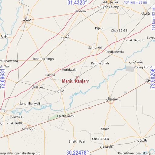
Mamu Kanjan GPS coordinates[2]
30° 49' 49.584" North, 72° 47' 57.948" East
| Map corner | latitude | longitude |
|---|---|---|
| Upper-left | 31.4323°, | 72.09631° |
| Center: | 30.83044°, | 72.79943° |
| Lower-right: | 30.22478°, | 73.50256° |
| Map W x H: | 134.3×134.3 km | = 83.5×83.5mi |
| max Lat: | 36.32162° ⇑47.6% North |
| Mamu Kanjan: | 30.83044° |
| min Lat: | ⇓52.4% South 24.14422° |
| min Long | Mamu Kanjan | max Long |
| 61.74573° | 72.79943° | 75.63372° |
| W 68.8%⇐ | ⇒31.2% E |
Elevation
Elevation of Mamu Kanjan is 167 m = 548 ft, and this is 178 m = 584 ft below average elevation for this country.
| Max E: |
2732 m = 8963 ft | 54% |
| Avg. | 345 m = 1132 ft | |
| Mamu Kanjan | 167 m = 548 ft | |
Min E: |
3 m = 10 ft | 46% |
See also: Pakistan elevation on elevation.city.
Geographical zone
Mamu Kanjan is located in North temperate zone (between Tropic of Cancer and the Arctic Circle). Distance of this Northern Tropic circle is 822.1 km =510.8 mi to South.| Distance of | km | miles | from Mamu Kanjan |
|---|---|---|---|
| North Pole | 6579 | 4088 | to North |
| Arctic Circle | 3973.2 | 2468.8 | to North |
| Tropic Cancer | 822.1 | 510.8 | to South |
| Equator | 3428 | 2130.1 | to South |


Nearby cities:
15 places around Mamu Kanjan: (largest is in red/bold)
• Bahawalnagar
64.5 km =40.1 mi,  118°
118°
• Chak Azam Sahu
23.5 km =14.6 mi,  111°
111°
• Chak One Hundred Twenty Nine Left
50.4 km =31.3 mi,  152°
152°
• Chak Thirty-one -Eleven Left
46.2 km =28.7 mi,  192°
192°
• Chichawatni
35 km =21.7 mi,  197°
197°
• Dijkot
46.9 km =29.1 mi,  23°
23°
• Gojra
37.1 km =23.1 mi,  342°
342°
• Kamalia
18.6 km =11.6 mi,  231°
231°
• Mian Channun
60.6 km =37.7 mi,  224°
224°
• Okara
62.3 km =38.7 mi,  92°
92°
• Pir Mahal
35.6 km =22.1 mi,  258°
258°
• Sahiwal
34.2 km =21.3 mi, 122°
• Talamba
63.2 km =39.3 mi,  237°
237°
• Tandlianwala
39 km =24.2 mi,  54°
54°
• Toba Tek Singh
34 km =21.1 mi,  297°
297°
Sources, notices
• [Note1] Compared only with cities in Pakistan existing in our database
• [Src1] Map data: © OpenStreetMap contributors (CC-BY-SA)
• [Src2] Other city data from geonames.org with taken over terms of usage.
• [Src3] Geographical zone / Annual Mean Temperature by Robert A. Rohde @ Wikipedia
