Toba Tek Singh geodata
Toba Tek Singh (Punjab) is a seat of a second-order administrative division; located in Pakistan in Asia/Karachi (GMT+5) time zone. With population of 69,064 people, there are 101 cities with bigger population in this country. Compared to other cities in Pakistan, 54.2% of cities are located further ↓South; 64.6% of cities are located further ←West and 55.8% of cities have higher elevation than Toba Tek Singh. Note1


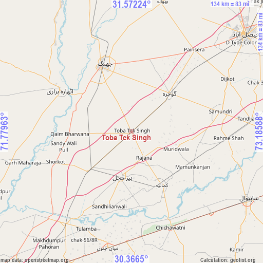
Toba Tek Singh GPS coordinates[2]
30° 58' 16.572" North, 72° 28' 57.9" East
| Map corner | latitude | longitude |
|---|---|---|
| Upper-left | 31.57224°, | 71.77963° |
| Center: | 30.97127°, | 72.48275° |
| Lower-right: | 30.3665°, | 73.18588° |
| Map W x H: | 134.1×134.1 km | = 83.3×83.3mi |
| max Lat: | 36.32162° ⇑45.8% North |
| Toba Tek Singh: | 30.97127° |
| min Lat: | ⇓54.2% South 24.14422° |
| min Long | Toba Tek Singh | max Long |
| 61.74573° | 72.48275° | 75.63372° |
| W 64.6%⇐ | ⇒35.4% E |
Elevation
Elevation of Toba Tek Singh is 161 m = 528 ft, and this is 184 m = 604 ft below average elevation for this country.
| Max E: |
2732 m = 8963 ft | 55.8% |
| Avg. | 345 m = 1132 ft | |
| Toba Tek Singh | 161 m = 528 ft | |
Min E: |
3 m = 10 ft | 44.2% |
See also: Toba Tek Singh elevation on elevation.city.
Geographical zone
Toba Tek Singh is located in North temperate zone (between Tropic of Cancer and the Arctic Circle). Distance of this Northern Tropic circle is 837.8 km =520.6 mi to South.| Distance of | km | miles | from Toba Tek Singh |
|---|---|---|---|
| North Pole | 6563.4 | 4078.3 | to North |
| Arctic Circle | 3957.5 | 2459.1 | to North |
| Tropic Cancer | 837.8 | 520.6 | to South |
| Equator | 3443.7 | 2139.8 | to South |


Nearby cities:
15 places around Toba Tek Singh: (largest is in red/bold)
• Chak Azam Sahu
57.5 km =35.7 mi,  115°
115°
• Chak Thirty-one -Eleven Left
64.2 km =39.9 mi,  161°
161°
• Chichawatni
53 km =32.9 mi, 157°
• Dijkot
56 km =34.8 mi,  60°
60°
• Garh Maharaja
57.2 km =35.5 mi,  254°
254°
• Gojra
27.5 km =17.1 mi,  43°
43°
• Jhang City
40.1 km =24.9 mi,  338°
338°
• Jhang Sadr
36.8 km =22.9 mi,  334°
334°
• Kamalia
31.3 km =19.4 mi,  150°
150°
• Mamu Kanjan
34 km =21.1 mi, 117°
• Mian Channun
60.2 km =37.4 mi,  191°
191°
• Pir Mahal
23.2 km =14.4 mi, 191°
• Sarai Sidhu
64.4 km =40 mi,  229°
229°
• Talamba
54.5 km =33.9 mi,  205°
205°
• Tandlianwala
62.3 km =38.7 mi,  83°
83°
Sources, notices
• [Note1] Compared only with cities in Pakistan existing in our database
• [Src1] Map data: © OpenStreetMap contributors (CC-BY-SA)
• [Src2] Other city data from geonames.org with taken over terms of usage.
• [Src3] Geographical zone / Annual Mean Temperature by Robert A. Rohde @ Wikipedia
