Kobiele Wielkie geodata
Kobiele Wielkie (Łódź Voivodeship) is a populated place; located in Poland in Europe/Warsaw (GMT+2) time zone. With population of 800 people, there are 2851 cities with bigger population in this country. Compared to other cities in Poland, 54.3% of cities are located further ↑North; 51.3% of cities are located further ←West and 76.5% of cities have lower elevation than Kobiele Wielkie. Note1
Administrative division(s):
- Level 1: Łódź Voivodeship
- Level 2: Powiat radomszczański
- Level 3: Kobiele Wielkie


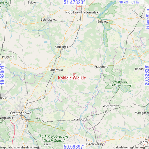
Kobiele Wielkie GPS coordinates[2]
51° 2' 17.556" North, 19° 37' 23.268" East
| Map corner | latitude | longitude |
|---|---|---|
| Upper-left | 51.47823°, | 18.92001° |
| Center: | 51.03821°, | 19.62313° |
| Lower-right: | 50.59397°, | 20.32626° |
| Map W x H: | 98.3×98.3 km | = 61.1×61.1mi |
| max Lat: | 54.83135° ⇑54.3% North |
| Kobiele Wielkie: | 51.03821° |
| min Lat: | ⇓45.7% South 49.21328° |
| min Long | Kobiele Wielkie | max Long |
| 14.20249° | 19.62313° | 24.03723° |
| W 51.3%⇐ | ⇒48.7% E |
Elevation
Elevation of Kobiele Wielkie is 252 m = 827 ft, and this is 60.6 m = 199 ft above average elevation for this country.
| Max E: |
974 m = 3196 ft | 23.5% |
| Kobiele Wielkie | 252 m 827 ft | |
| Avg. | 191.4 m = 628 ft | |
Min E: |
-3 m = -10 ft | 76.5% |
See also: Poland elevation on elevation.city.
Geographical zone
Kobiele Wielkie is located in North temperate zone (between Tropic of Cancer and the Arctic Circle). Distance of this North polar circle is 1726.3 km =1072.7 mi to North.| Distance of | km | miles | from Kobiele Wielkie |
|---|---|---|---|
| North Pole | 4332.1 | 2691.8 | to North |
| Arctic Circle | 1726.3 | 1072.7 | to North |
| Tropic Cancer | 3069 | 1907 | to South |
| Equator | 5674.9 | 3526.2 | to South |


Nearby cities:
15 places around Kobiele Wielkie: (largest is in red/bold)
• Dobroszyce
18.9 km =11.7 mi,  308°
308°
• Dąbrowa Zielona
22.1 km =13.7 mi,  192°
192°
• Gidle
13.6 km =8.5 mi,  231°
231°
• Gomunice
17.1 km =10.6 mi,  328°
328°
• Gorzkowice
19.8 km =12.3 mi,  354°
354°
• Kamieńsk
20.3 km =12.6 mi, 334°
• Kodrąb
6.9 km =4.3 mi,  3°
3°
• Przedbórz
18.4 km =11.4 mi,  72°
72°
• Pławno
13.5 km =8.4 mi,  240°
240°
• Radomsko
12.9 km =8 mi,  284°
284°
• Radziechowice Pierwsze
21.1 km =13.1 mi, 279°
• Soborzyce
19.9 km =12.4 mi,  181°
181°
• Wielgomłyny
10.2 km =6.3 mi,  105°
105°
• Łęki Szlacheckie
20.6 km =12.8 mi,  36°
36°
• Żytno
12.3 km =7.6 mi, 178°
Sources, notices
• [Note1] Compared only with cities in Poland existing in our database
• [Src1] Map data: © OpenStreetMap contributors (CC-BY-SA)
• [Src2] Other city data from geonames.org with taken over terms of usage.
• [Src3] Geographical zone / Annual Mean Temperature by Robert A. Rohde @ Wikipedia
