Przedbórz geodata
Przedbórz (Łódź Voivodeship) is a seat of a third-order administrative division; located in Poland in Europe/Warsaw (GMT+2) time zone. With population of 3,765 people, there are 862 cities with bigger population in this country. Compared to other cities in Poland, 53.1% of cities are located further ↑North; 56.4% of cities are located further ←West and 59.4% of cities have lower elevation than Przedbórz. Note1
Administrative division(s):
- Level 1: Łódź Voivodeship
- Level 2: Powiat radomszczański
- Level 3: Przedbórz


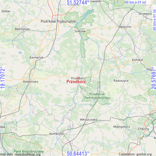
Przedbórz GPS coordinates[2]
51° 5' 16.404" North, 19° 52' 25.824" East
| Map corner | latitude | longitude |
|---|---|---|
| Upper-left | 51.52744°, | 19.17072° |
| Center: | 51.08789°, | 19.87384° |
| Lower-right: | 50.64413°, | 20.57697° |
| Map W x H: | 98.2×98.2 km | = 61×61mi |
| max Lat: | 54.83135° ⇑53.1% North |
| Przedbórz: | 51.08789° |
| min Lat: | ⇓46.9% South 49.21328° |
| min Long | Przedbórz | max Long |
| 14.20249° | 19.87384° | 24.03723° |
| W 56.4%⇐ | ⇒43.6% E |
Elevation
Elevation of Przedbórz is 199 m = 653 ft, and this is 7.6 m = 25 ft above average elevation for this country.
| Max E: |
974 m = 3196 ft | 40.6% |
| Przedbórz | 199 m 653 ft | |
| Avg. | 191.4 m = 628 ft | |
Min E: |
-3 m = -10 ft | 59.4% |
See also: Poland elevation on elevation.city.
Geographical zone
Przedbórz is located in North temperate zone (between Tropic of Cancer and the Arctic Circle). Distance of this North polar circle is 1720.7 km =1069.2 mi to North.| Distance of | km | miles | from Przedbórz |
|---|---|---|---|
| North Pole | 4326.6 | 2688.4 | to North |
| Arctic Circle | 1720.7 | 1069.2 | to North |
| Tropic Cancer | 3074.5 | 1910.4 | to South |
| Equator | 5680.4 | 3529.6 | to South |


Nearby cities:
15 places around Przedbórz: (largest is in red/bold)
• Aleksandrów
21.9 km =13.6 mi,  21°
21°
• Czermno
11 km =6.8 mi,  77°
77°
• Fałków
17.1 km =10.6 mi,  71°
71°
• Gorzkowice
24 km =14.9 mi,  306°
306°
• Kluczewsko
18.1 km =11.2 mi,  169°
169°
• Kobiele Wielkie
18.4 km =11.4 mi,  252°
252°
• Kodrąb
17.2 km =10.7 mi,  274°
274°
• Radoszyce
26.9 km =16.7 mi,  93°
93°
• Ruda Maleniecka
25.3 km =15.7 mi, 75°
• Ręczno
11.5 km =7.1 mi,  352°
352°
• Słupia
20.4 km =12.7 mi,  113°
113°
• Wielgomłyny
11.3 km =7 mi,  222°
222°
• Włoszczowa
26.9 km =16.7 mi, 166°
• Łęki Szlacheckie
12.3 km =7.6 mi,  334°
334°
• Żytno
24.8 km =15.4 mi, 223°
Sources, notices
• [Note1] Compared only with cities in Poland existing in our database
• [Src1] Map data: © OpenStreetMap contributors (CC-BY-SA)
• [Src2] Other city data from geonames.org with taken over terms of usage.
• [Src3] Geographical zone / Annual Mean Temperature by Robert A. Rohde @ Wikipedia
