Wielgomłyny geodata
Wielgomłyny (Łódź Voivodeship) is a populated place; located in Poland in Europe/Warsaw (GMT+2) time zone. With population of 850 people, there are 2772 cities with bigger population in this country. Compared to other cities in Poland, 55.2% of cities are located further ↑North; 54% of cities are located further ←West and 64.1% of cities have lower elevation than Wielgomłyny. Note1
Administrative division(s):
- Level 1: Łódź Voivodeship
- Level 2: Powiat radomszczański
- Level 3: Wielgomłyny


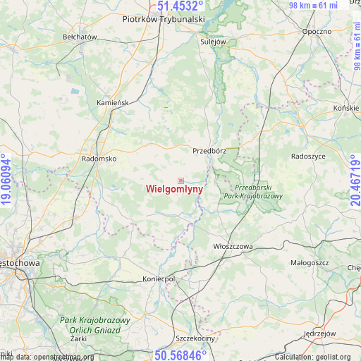
Wielgomłyny GPS coordinates[2]
51° 0' 46.584" North, 19° 45' 50.616" East
| Map corner | latitude | longitude |
|---|---|---|
| Upper-left | 51.4532°, | 19.06094° |
| Center: | 51.01294°, | 19.76406° |
| Lower-right: | 50.56846°, | 20.46719° |
| Map W x H: | 98.4×98.4 km | = 61.1×61.1mi |
| max Lat: | 54.83135° ⇑55.2% North |
| Wielgomłyny: | 51.01294° |
| min Lat: | ⇓44.8% South 49.21328° |
| min Long | Wielgomłyny | max Long |
| 14.20249° | 19.76406° | 24.03723° |
| W 54%⇐ | ⇒46% E |
Elevation
Elevation of Wielgomłyny is 212 m = 696 ft, and this is 20.6 m = 68 ft above average elevation for this country.
| Max E: |
974 m = 3196 ft | 35.9% |
| Wielgomłyny | 212 m 696 ft | |
| Avg. | 191.4 m = 628 ft | |
Min E: |
-3 m = -10 ft | 64.1% |
See also: Poland elevation on elevation.city.
Geographical zone
Wielgomłyny is located in North temperate zone (between Tropic of Cancer and the Arctic Circle). Distance of this North polar circle is 1729.1 km =1074.4 mi to North.| Distance of | km | miles | from Wielgomłyny |
|---|---|---|---|
| North Pole | 4335 | 2693.6 | to North |
| Arctic Circle | 1729.1 | 1074.4 | to North |
| Tropic Cancer | 3066.2 | 1905.2 | to South |
| Equator | 5672.1 | 3524.5 | to South |


Nearby cities:
15 places around Wielgomłyny: (largest is in red/bold)
• Czermno
21.3 km =13.2 mi,  59°
59°
• Dąbrowa Zielona
23.8 km =14.8 mi,  217°
217°
• Gidle
21.2 km =13.2 mi,  254°
254°
• Gorzkowice
25.4 km =15.8 mi,  332°
332°
• Kluczewsko
14.4 km =8.9 mi,  131°
131°
• Kobiele Wielkie
10.2 km =6.3 mi,  285°
285°
• Kodrąb
13.5 km =8.4 mi,  315°
315°
• Przedbórz
11.3 km =7 mi,  42°
42°
• Pławno
22 km =13.7 mi,  259°
259°
• Radomsko
23.1 km =14.4 mi, 285°
• Ręczno
20.7 km =12.9 mi,  17°
17°
• Soborzyce
20 km =12.4 mi,  211°
211°
• Włoszczowa
22.8 km =14.2 mi,  141°
141°
• Łęki Szlacheckie
19.6 km =12.2 mi,  6°
6°
• Żytno
13.5 km =8.4 mi,  225°
225°
Sources, notices
• [Note1] Compared only with cities in Poland existing in our database
• [Src1] Map data: © OpenStreetMap contributors (CC-BY-SA)
• [Src2] Other city data from geonames.org with taken over terms of usage.
• [Src3] Geographical zone / Annual Mean Temperature by Robert A. Rohde @ Wikipedia
