Lisewo geodata
Lisewo (Greater Poland) is a populated place; located in Poland in Europe/Warsaw (GMT+2) time zone. With population of 516 people, there are 3500 cities with bigger population in this country. Compared to other cities in Poland, 67.4% of cities are located further ↓South; 78.3% of cities are located further →East and 89.2% of cities have higher elevation than Lisewo. Note1


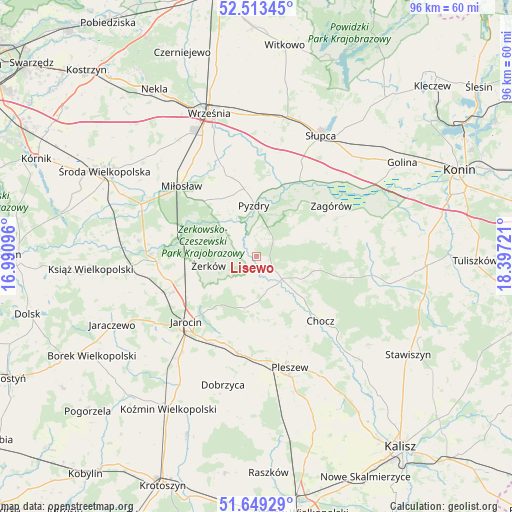
Lisewo GPS coordinates[2]
52° 5' 0.456" North, 17° 41' 38.688" East
| Map corner | latitude | longitude |
|---|---|---|
| Upper-left | 52.51345°, | 16.99096° |
| Center: | 52.08346°, | 17.69408° |
| Lower-right: | 51.64929°, | 18.39721° |
| Map W x H: | 96.1×96.1 km | = 59.7×59.7mi |
| max Lat: | 54.83135° ⇑32.6% North |
| Lisewo: | 52.08346° |
| min Lat: | ⇓67.4% South 49.21328° |
| min Long | Lisewo | max Long |
| 14.20249° | 17.69408° | 24.03723° |
| W 21.7%⇐ | ⇒78.3% E |
Elevation
Elevation of Lisewo is 78 m = 256 ft, and this is 113.4 m = 372 ft below average elevation for this country.
| Max E: |
974 m = 3196 ft | 89.2% |
| Avg. | 191.4 m = 628 ft | |
| Lisewo | 78 m = 256 ft | |
Min E: |
-3 m = -10 ft | 10.8% |
See also: Poland elevation on elevation.city.
Geographical zone
Lisewo is located in North temperate zone (between Tropic of Cancer and the Arctic Circle). Distance of this North polar circle is 1610 km =1000.4 mi to North.| Distance of | km | miles | from Lisewo |
|---|---|---|---|
| North Pole | 4215.9 | 2619.6 | to North |
| Arctic Circle | 1610 | 1000.4 | to North |
| Tropic Cancer | 3185.2 | 1979.2 | to South |
| Equator | 5791.1 | 3598.4 | to South |


Nearby cities:
15 places around Lisewo: (largest is in red/bold)
• Broniszewice
15.4 km =9.6 mi,  147°
147°
• Chocz
16.9 km =10.5 mi,  134°
134°
• Czermin
15.3 km =9.5 mi,  165°
165°
• Dobieszczyzna
6.4 km =4 mi,  192°
192°
• Gizałki
6.9 km =4.3 mi, 131°
• Grabowo Królewskie
18.3 km =11.4 mi,  344°
344°
• Jarocin
18 km =11.2 mi,  226°
226°
• Kotlin
18.5 km =11.5 mi, 189°
• Kołaczkowo
15.6 km =9.7 mi, 342°
• Pyzdry
9.7 km =6 mi,  358°
358°
• Sokolniki
18.8 km =11.7 mi,  2°
2°
• Tomice
3.5 km =2.2 mi,  122°
122°
• Witaszyce
18.2 km =11.3 mi,  209°
209°
• Zagórów
16.7 km =10.4 mi,  55°
55°
• Żerków
9.1 km =5.7 mi,  259°
259°
Sources, notices
• [Note1] Compared only with cities in Poland existing in our database
• [Src1] Map data: © OpenStreetMap contributors (CC-BY-SA)
• [Src2] Other city data from geonames.org with taken over terms of usage.
• [Src3] Geographical zone / Annual Mean Temperature by Robert A. Rohde @ Wikipedia
