Pyzdry geodata
Pyzdry (Greater Poland) is a seat of a third-order administrative division; located in Poland in Europe/Warsaw (GMT+2) time zone. With population of 3,203 people, there are 989 cities with bigger population in this country. Compared to other cities in Poland, 69.3% of cities are located further ↓South; 78.4% of cities are located further →East and 85.2% of cities have higher elevation than Pyzdry. Note1


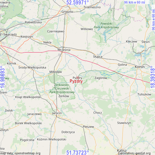
Pyzdry GPS coordinates[2]
52° 10' 14.016" North, 17° 41' 24.18" East
| Map corner | latitude | longitude |
|---|---|---|
| Upper-left | 52.59971°, | 16.98693° |
| Center: | 52.17056°, | 17.69005° |
| Lower-right: | 51.73723°, | 18.39318° |
| Map W x H: | 95.9×95.9 km | = 59.6×59.6mi |
| max Lat: | 54.83135° ⇑30.7% North |
| Pyzdry: | 52.17056° |
| min Lat: | ⇓69.3% South 49.21328° |
| min Long | Pyzdry | max Long |
| 14.20249° | 17.69005° | 24.03723° |
| W 21.6%⇐ | ⇒78.4% E |
Elevation
Elevation of Pyzdry is 89 m = 292 ft, and this is 102.4 m = 336 ft below average elevation for this country.
| Max E: |
974 m = 3196 ft | 85.2% |
| Avg. | 191.4 m = 628 ft | |
| Pyzdry | 89 m = 292 ft | |
Min E: |
-3 m = -10 ft | 14.8% |
See also: Poland elevation on elevation.city.
Geographical zone
Pyzdry is located in North temperate zone (between Tropic of Cancer and the Arctic Circle). Distance of this North polar circle is 1600.4 km =994.4 mi to North.| Distance of | km | miles | from Pyzdry |
|---|---|---|---|
| North Pole | 4206.2 | 2613.6 | to North |
| Arctic Circle | 1600.4 | 994.4 | to North |
| Tropic Cancer | 3194.9 | 1985.2 | to South |
| Equator | 5800.8 | 3604.4 | to South |


Nearby cities:
15 places around Pyzdry: (largest is in red/bold)
• Dobieszczyzna
16 km =9.9 mi,  184°
184°
• Gizałki
15.2 km =9.4 mi,  159°
159°
• Grabowo Królewskie
9.2 km =5.7 mi,  329°
329°
• Kołaczkowo
6.9 km =4.3 mi,  319°
319°
• Lisewo
9.7 km =6 mi, 178°
• Lądek
16.9 km =10.5 mi,  75°
75°
• Miłosław
14.1 km =8.8 mi,  284°
284°
• Nowe Miasto nad Wartą
21 km =13 mi,  244°
244°
• Sokolniki
9.1 km =5.7 mi,  7°
7°
• Strzałkowo
17.5 km =10.9 mi,  29°
29°
• Słupca
17.9 km =11.1 mi,  43°
43°
• Tomice
12 km =7.5 mi, 164°
• Września
19.2 km =11.9 mi, 333°
• Zagórów
14 km =8.7 mi,  91°
91°
• Żerków
14.2 km =8.8 mi,  217°
217°
Sources, notices
• [Note1] Compared only with cities in Poland existing in our database
• [Src1] Map data: © OpenStreetMap contributors (CC-BY-SA)
• [Src2] Other city data from geonames.org with taken over terms of usage.
• [Src3] Geographical zone / Annual Mean Temperature by Robert A. Rohde @ Wikipedia
