Kołaczkowo geodata
Kołaczkowo (Greater Poland) is a seat of a third-order administrative division; located in Poland in Europe/Warsaw (GMT+2) time zone. With population of 753 people, there are 2946 cities with bigger population in this country. Compared to other cities in Poland, 70.6% of cities are located further ↓South; 79% of cities are located further →East and 81.2% of cities have higher elevation than Kołaczkowo. Note1


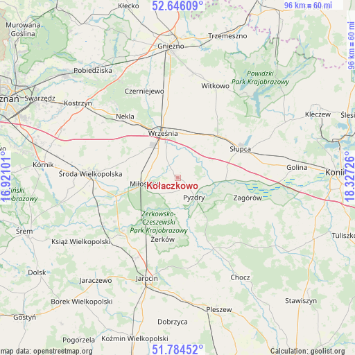
Kołaczkowo GPS coordinates[2]
52° 13' 2.604" North, 17° 37' 26.868" East
| Map corner | latitude | longitude |
|---|---|---|
| Upper-left | 52.64609°, | 16.92101° |
| Center: | 52.21739°, | 17.62413° |
| Lower-right: | 51.78452°, | 18.32726° |
| Map W x H: | 95.8×95.8 km | = 59.5×59.5mi |
| max Lat: | 54.83135° ⇑29.4% North |
| Kołaczkowo: | 52.21739° |
| min Lat: | ⇓70.6% South 49.21328° |
| min Long | Kołaczkowo | max Long |
| 14.20249° | 17.62413° | 24.03723° |
| W 21%⇐ | ⇒79% E |
Elevation
Elevation of Kołaczkowo is 97 m = 318 ft, and this is 94.4 m = 310 ft below average elevation for this country.
| Max E: |
974 m = 3196 ft | 81.2% |
| Avg. | 191.4 m = 628 ft | |
| Kołaczkowo | 97 m = 318 ft | |
Min E: |
-3 m = -10 ft | 18.8% |
See also: Poland elevation on elevation.city.
Geographical zone
Kołaczkowo is located in North temperate zone (between Tropic of Cancer and the Arctic Circle). Distance of this North polar circle is 1595.1 km =991.1 mi to North.| Distance of | km | miles | from Kołaczkowo |
|---|---|---|---|
| North Pole | 4201 | 2610.4 | to North |
| Arctic Circle | 1595.1 | 991.1 | to North |
| Tropic Cancer | 3200.1 | 1988.4 | to South |
| Equator | 5806 | 3607.7 | to South |


Nearby cities:
15 places around Kołaczkowo: (largest is in red/bold)
• Dominowo
19.9 km =12.4 mi,  294°
294°
• Grabowo Królewskie
2.7 km =1.7 mi,  355°
355°
• Krzykosy
20.8 km =12.9 mi,  235°
235°
• Lisewo
15.6 km =9.7 mi,  162°
162°
• Lądek
20.9 km =13 mi,  92°
92°
• Miłosław
9.3 km =5.8 mi,  260°
260°
• Nowe Miasto nad Wartą
20.3 km =12.6 mi,  225°
225°
• Pyzdry
6.9 km =4.3 mi,  139°
139°
• Sokolniki
6.9 km =4.3 mi,  55°
55°
• Strzałkowo
16.5 km =10.3 mi,  52°
52°
• Słupca
18.6 km =11.6 mi,  65°
65°
• Tomice
18.5 km =11.5 mi, 155°
• Września
12.6 km =7.8 mi,  341°
341°
• Zagórów
19.3 km =12 mi,  106°
106°
• Żerków
17 km =10.6 mi,  194°
194°
Sources, notices
• [Note1] Compared only with cities in Poland existing in our database
• [Src1] Map data: © OpenStreetMap contributors (CC-BY-SA)
• [Src2] Other city data from geonames.org with taken over terms of usage.
• [Src3] Geographical zone / Annual Mean Temperature by Robert A. Rohde @ Wikipedia
