Olesno geodata
Olesno (Opole Voivodeship) is a seat of a third-order administrative division; located in Poland in Europe/Warsaw (GMT+2) time zone. With population of 10,236 people, there are 438 cities with bigger population in this country. Compared to other cities in Poland, 58.4% of cities are located further ↑North; 69.3% of cities are located further →East and 72.8% of cities have lower elevation than Olesno. Note1


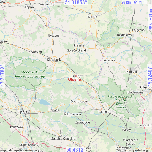
Olesno GPS coordinates[2]
50° 52' 37.128" North, 18° 25' 15.384" East
| Map corner | latitude | longitude |
|---|---|---|
| Upper-left | 51.31853°, | 17.71782° |
| Center: | 50.87698°, | 18.42094° |
| Lower-right: | 50.4312°, | 19.12407° |
| Map W x H: | 98.7×98.7 km | = 61.3×61.3mi |
| max Lat: | 54.83135° ⇑58.4% North |
| Olesno: | 50.87698° |
| min Lat: | ⇓41.6% South 49.21328° |
| min Long | Olesno | max Long |
| 14.20249° | 18.42094° | 24.03723° |
| W 30.7%⇐ | ⇒69.3% E |
Elevation
Elevation of Olesno is 239 m = 784 ft, and this is 47.6 m = 156 ft above average elevation for this country.
| Max E: |
974 m = 3196 ft | 27.2% |
| Olesno | 239 m 784 ft | |
| Avg. | 191.4 m = 628 ft | |
Min E: |
-3 m = -10 ft | 72.8% |
See also: Poland elevation on elevation.city.
Geographical zone
Olesno is located in North temperate zone (between Tropic of Cancer and the Arctic Circle). Distance of this North polar circle is 1744.2 km =1083.8 mi to North.| Distance of | km | miles | from Olesno |
|---|---|---|---|
| North Pole | 4350.1 | 2703 | to North |
| Arctic Circle | 1744.2 | 1083.8 | to North |
| Tropic Cancer | 3051.1 | 1895.9 | to South |
| Equator | 5657 | 3515.1 | to South |


Nearby cities:
15 places around Olesno: (largest is in red/bold)
• Bierdzany
19.6 km =12.2 mi,  250°
250°
• Ciasna
19 km =11.8 mi,  136°
136°
• Dobrodzień
16.6 km =10.3 mi,  174°
174°
• Gorzów Śląski
16.9 km =10.5 mi,  0°
0°
• Gwoździany
18.8 km =11.7 mi,  156°
156°
• Kluczbork
17.8 km =11.1 mi,  306°
306°
• Lasowice Małe
12 km =7.5 mi,  284°
284°
• Lasowice Wielkie
13.6 km =8.5 mi,  266°
266°
• Praszka
19.8 km =12.3 mi,  6°
6°
• Przystajń
19 km =11.8 mi,  87°
87°
• Radłow
10.2 km =6.3 mi,  52°
52°
• Sieraków Śląski
13.6 km =8.5 mi,  127°
127°
• Starokrzepice
18.1 km =11.2 mi,  63°
63°
• Wojciechów
3 km =1.9 mi,  317°
317°
• Zębowice
13.8 km =8.6 mi,  202°
202°
Sources, notices
• [Note1] Compared only with cities in Poland existing in our database
• [Src1] Map data: © OpenStreetMap contributors (CC-BY-SA)
• [Src2] Other city data from geonames.org with taken over terms of usage.
• [Src3] Geographical zone / Annual Mean Temperature by Robert A. Rohde @ Wikipedia
