Wojciechów geodata
Wojciechów (Opole Voivodeship) is a populated place; located in Poland in Europe/Warsaw (GMT+2) time zone. With population of 972 people, there are 2548 cities with bigger population in this country. Compared to other cities in Poland, 57.9% of cities are located further ↑North; 69.8% of cities are located further →East and 68.1% of cities have lower elevation than Wojciechów. Note1


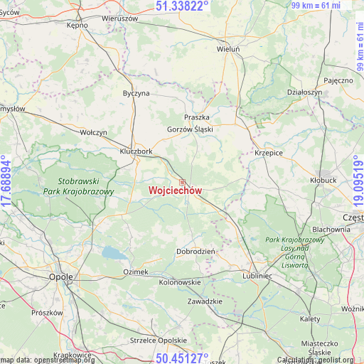
Wojciechów GPS coordinates[2]
50° 53' 48.696" North, 18° 23' 31.416" East
| Map corner | latitude | longitude |
|---|---|---|
| Upper-left | 51.33822°, | 17.68894° |
| Center: | 50.89686°, | 18.39206° |
| Lower-right: | 50.45127°, | 19.09519° |
| Map W x H: | 98.6×98.6 km | = 61.3×61.3mi |
| max Lat: | 54.83135° ⇑57.9% North |
| Wojciechów: | 50.89686° |
| min Lat: | ⇓42.1% South 49.21328° |
| min Long | Wojciechów | max Long |
| 14.20249° | 18.39206° | 24.03723° |
| W 30.2%⇐ | ⇒69.8% E |
Elevation
Elevation of Wojciechów is 223 m = 732 ft, and this is 31.6 m = 104 ft above average elevation for this country.
| Max E: |
974 m = 3196 ft | 31.9% |
| Wojciechów | 223 m 732 ft | |
| Avg. | 191.4 m = 628 ft | |
Min E: |
-3 m = -10 ft | 68.1% |
See also: Poland elevation on elevation.city.
Geographical zone
Wojciechów is located in North temperate zone (between Tropic of Cancer and the Arctic Circle). Distance of this North polar circle is 1742 km =1082.4 mi to North.| Distance of | km | miles | from Wojciechów |
|---|---|---|---|
| North Pole | 4347.9 | 2701.7 | to North |
| Arctic Circle | 1742 | 1082.4 | to North |
| Tropic Cancer | 3053.3 | 1897.2 | to South |
| Equator | 5659.2 | 3516.5 | to South |


Nearby cities:
15 places around Wojciechów: (largest is in red/bold)
• Bierdzany
18.6 km =11.6 mi,  242°
242°
• Borkowice
17.1 km =10.6 mi,  286°
286°
• Dobrodzień
19.1 km =11.9 mi,  168°
168°
• Gorzów Śląski
14.8 km =9.2 mi,  8°
8°
• Kluczbork
14.8 km =9.2 mi,  304°
304°
• Kowale
21.1 km =13.1 mi,  15°
15°
• Lasowice Małe
9.6 km =6 mi,  275°
275°
• Lasowice Wielkie
12 km =7.5 mi,  255°
255°
• Olesno
3 km =1.9 mi,  137°
137°
• Praszka
18 km =11.2 mi, 13°
• Przystajń
21.1 km =13.1 mi,  93°
93°
• Radłow
10.8 km =6.7 mi,  68°
68°
• Sieraków Śląski
16.6 km =10.3 mi,  129°
129°
• Starokrzepice
19.2 km =11.9 mi, 72°
• Zębowice
15.3 km =9.5 mi,  192°
192°
Sources, notices
• [Note1] Compared only with cities in Poland existing in our database
• [Src1] Map data: © OpenStreetMap contributors (CC-BY-SA)
• [Src2] Other city data from geonames.org with taken over terms of usage.
• [Src3] Geographical zone / Annual Mean Temperature by Robert A. Rohde @ Wikipedia
