Pawonków geodata
Pawonków (Silesia) is a populated place; located in Poland in Europe/Warsaw (GMT+2) time zone. With population of 1,496 people, there are 1882 cities with bigger population in this country. Compared to other cities in Poland, 62.8% of cities are located further ↑North; 66.9% of cities are located further →East and 79% of cities have lower elevation than Pawonków. Note1


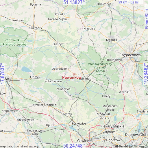
Pawonków GPS coordinates[2]
50° 41' 41.964" North, 18° 34' 53.364" East
| Map corner | latitude | longitude |
|---|---|---|
| Upper-left | 51.13827°, | 17.87837° |
| Center: | 50.69499°, | 18.58149° |
| Lower-right: | 50.24748°, | 19.28462° |
| Map W x H: | 99×99 km | = 61.5×61.5mi |
| max Lat: | 54.83135° ⇑62.8% North |
| Pawonków: | 50.69499° |
| min Lat: | ⇓37.2% South 49.21328° |
| min Long | Pawonków | max Long |
| 14.20249° | 18.58149° | 24.03723° |
| W 33.1%⇐ | ⇒66.9% E |
Elevation
Elevation of Pawonków is 261 m = 856 ft, and this is 69.6 m = 228 ft above average elevation for this country.
| Max E: |
974 m = 3196 ft | 21% |
| Pawonków | 261 m 856 ft | |
| Avg. | 191.4 m = 628 ft | |
Min E: |
-3 m = -10 ft | 79% |
See also: Poland elevation on elevation.city.
Geographical zone
Pawonków is located in North temperate zone (between Tropic of Cancer and the Arctic Circle). Distance of this North polar circle is 1764.4 km =1096.3 mi to North.| Distance of | km | miles | from Pawonków |
|---|---|---|---|
| North Pole | 4370.3 | 2715.6 | to North |
| Arctic Circle | 1764.4 | 1096.3 | to North |
| Tropic Cancer | 3030.8 | 1883.3 | to South |
| Equator | 5636.8 | 3502.5 | to South |


Nearby cities:
15 places around Pawonków: (largest is in red/bold)
• Ciasna
6.9 km =4.3 mi,  16°
16°
• Dobrodzień
10.3 km =6.4 mi,  291°
291°
• Gwoździany
4.7 km =2.9 mi,  309°
309°
• Jemielnica
21.9 km =13.6 mi,  220°
220°
• Kochanowice
11.9 km =7.4 mi,  84°
84°
• Kolonowskie
14.6 km =9.1 mi,  251°
251°
• Koszęcin
19.5 km =12.1 mi,  110°
110°
• Krupski Młyn
13.8 km =8.6 mi,  167°
167°
• Lubliniec
7.8 km =4.8 mi, 111°
• Sieraków Śląski
12 km =7.5 mi,  357°
357°
• Tworóg
20.5 km =12.7 mi,  152°
152°
• Wielowieś
20.8 km =12.9 mi, 173°
• Zawadzkie
12.1 km =7.5 mi,  214°
214°
• Zębowice
18.3 km =11.4 mi, 294°
• Łaziska
19.4 km =12.1 mi,  231°
231°
Sources, notices
• [Note1] Compared only with cities in Poland existing in our database
• [Src1] Map data: © OpenStreetMap contributors (CC-BY-SA)
• [Src2] Other city data from geonames.org with taken over terms of usage.
• [Src3] Geographical zone / Annual Mean Temperature by Robert A. Rohde @ Wikipedia
