Ciasna geodata
Ciasna (Silesia) is a populated place; located in Poland in Europe/Warsaw (GMT+2) time zone. With population of 1,722 people, there are 1663 cities with bigger population in this country. Compared to other cities in Poland, 61.2% of cities are located further ↑North; 66.5% of cities are located further →East and 74.2% of cities have lower elevation than Ciasna. Note1


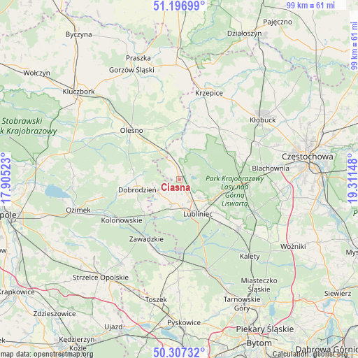
Ciasna GPS coordinates[2]
50° 45' 15.372" North, 18° 36' 30.06" East
| Map corner | latitude | longitude |
|---|---|---|
| Upper-left | 51.19699°, | 17.90523° |
| Center: | 50.75427°, | 18.60835° |
| Lower-right: | 50.30732°, | 19.31148° |
| Map W x H: | 98.9×98.9 km | = 61.5×61.5mi |
| max Lat: | 54.83135° ⇑61.2% North |
| Ciasna: | 50.75427° |
| min Lat: | ⇓38.8% South 49.21328° |
| min Long | Ciasna | max Long |
| 14.20249° | 18.60835° | 24.03723° |
| W 33.5%⇐ | ⇒66.5% E |
Elevation
Elevation of Ciasna is 243 m = 797 ft, and this is 51.6 m = 169 ft above average elevation for this country.
| Max E: |
974 m = 3196 ft | 25.8% |
| Ciasna | 243 m 797 ft | |
| Avg. | 191.4 m = 628 ft | |
Min E: |
-3 m = -10 ft | 74.2% |
See also: Poland elevation on elevation.city.
Geographical zone
Ciasna is located in North temperate zone (between Tropic of Cancer and the Arctic Circle). Distance of this North polar circle is 1757.8 km =1092.2 mi to North.| Distance of | km | miles | from Ciasna |
|---|---|---|---|
| North Pole | 4363.7 | 2711.5 | to North |
| Arctic Circle | 1757.8 | 1092.2 | to North |
| Tropic Cancer | 3037.4 | 1887.4 | to South |
| Equator | 5643.3 | 3506.6 | to South |


Nearby cities:
15 places around Ciasna: (largest is in red/bold)
• Dobrodzień
11.8 km =7.3 mi,  256°
256°
• Gwoździany
6.6 km =4.1 mi,  237°
237°
• Herby
19.6 km =12.2 mi,  90°
90°
• Kochanowice
11.3 km =7 mi,  118°
118°
• Kolonowskie
19.3 km =12 mi,  234°
234°
• Krupski Młyn
20.1 km =12.5 mi,  177°
177°
• Lubliniec
10.9 km =6.8 mi,  150°
150°
• Olesno
19 km =11.8 mi,  316°
316°
• Panki
17.5 km =10.9 mi,  35°
35°
• Pawonków
6.9 km =4.3 mi,  196°
196°
• Przystajń
15.7 km =9.8 mi,  21°
21°
• Sieraków Śląski
5.9 km =3.7 mi,  336°
336°
• Truskolasy
19.8 km =12.3 mi,  50°
50°
• Zawadzkie
18.7 km =11.6 mi,  207°
207°
• Zębowice
18.6 km =11.6 mi,  272°
272°
Sources, notices
• [Note1] Compared only with cities in Poland existing in our database
• [Src1] Map data: © OpenStreetMap contributors (CC-BY-SA)
• [Src2] Other city data from geonames.org with taken over terms of usage.
• [Src3] Geographical zone / Annual Mean Temperature by Robert A. Rohde @ Wikipedia
