Sieraków Śląski geodata
Sieraków Śląski (Silesia) is a populated place; located in Poland in Europe/Warsaw (GMT+2) time zone. With population of 1,704 people, there are 1676 cities with bigger population in this country. Compared to other cities in Poland, 60.1% of cities are located further ↑North; 67.1% of cities are located further →East and 75.1% of cities have lower elevation than Sieraków Śląski. Note1


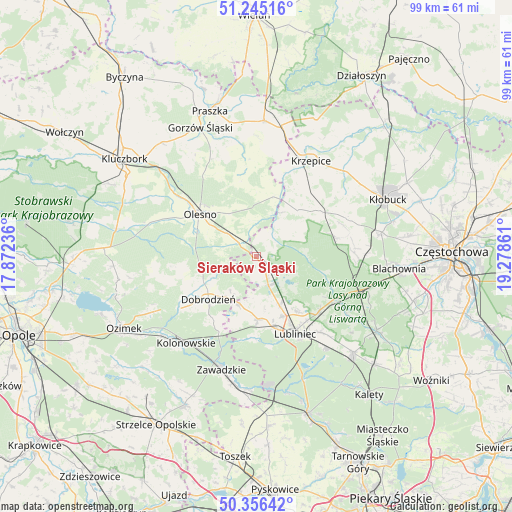
Sieraków Śląski GPS coordinates[2]
50° 48' 10.44" North, 18° 34' 31.728" East
| Map corner | latitude | longitude |
|---|---|---|
| Upper-left | 51.24516°, | 17.87236° |
| Center: | 50.8029°, | 18.57548° |
| Lower-right: | 50.35642°, | 19.27861° |
| Map W x H: | 98.8×98.8 km | = 61.4×61.4mi |
| max Lat: | 54.83135° ⇑60.1% North |
| Sieraków Śląski: | 50.8029° |
| min Lat: | ⇓39.9% South 49.21328° |
| min Long | Sieraków Ślą | max Long |
| 14.20249° | 18.57548° | 24.03723° |
| W 32.9%⇐ | ⇒67.1% E |
Elevation
Elevation of Sieraków Śląski is 247 m = 810 ft, and this is 55.6 m = 182 ft above average elevation for this country.
| Max E: |
974 m = 3196 ft | 24.9% |
| Sieraków Śląski | 247 m 810 ft | |
| Avg. | 191.4 m = 628 ft | |
Min E: |
-3 m = -10 ft | 75.1% |
See also: Poland elevation on elevation.city.
Geographical zone
Sieraków Śląski is located in North temperate zone (between Tropic of Cancer and the Arctic Circle). Distance of this North polar circle is 1752.4 km =1088.9 mi to North.| Distance of | km | miles | from Sieraków Śląski |
|---|---|---|---|
| North Pole | 4358.3 | 2708.1 | to North |
| Arctic Circle | 1752.4 | 1088.9 | to North |
| Tropic Cancer | 3042.8 | 1890.7 | to South |
| Equator | 5648.8 | 3510 | to South |


Nearby cities:
15 places around Sieraków Śląski: (largest is in red/bold)
• Ciasna
5.9 km =3.7 mi,  156°
156°
• Dobrodzień
12.3 km =7.6 mi,  228°
228°
• Gwoździany
9.5 km =5.9 mi,  199°
199°
• Kochanowice
16.3 km =10.1 mi,  131°
131°
• Kolonowskie
21.4 km =13.3 mi,  218°
218°
• Lubliniec
16.7 km =10.4 mi,  152°
152°
• Olesno
13.6 km =8.5 mi,  307°
307°
• Panki
15.3 km =9.5 mi,  54°
54°
• Pawonków
12 km =7.5 mi,  177°
177°
• Przystajń
12.2 km =7.6 mi,  41°
41°
• Radłow
14.8 km =9.2 mi,  348°
348°
• Starokrzepice
17.1 km =10.6 mi,  18°
18°
• Truskolasy
19 km =11.8 mi,  68°
68°
• Wojciechów
16.6 km =10.3 mi, 309°
• Zębowice
16.8 km =10.4 mi,  254°
254°
Sources, notices
• [Note1] Compared only with cities in Poland existing in our database
• [Src1] Map data: © OpenStreetMap contributors (CC-BY-SA)
• [Src2] Other city data from geonames.org with taken over terms of usage.
• [Src3] Geographical zone / Annual Mean Temperature by Robert A. Rohde @ Wikipedia
