Krupski Młyn geodata
Krupski Młyn (Silesia) is a seat of a third-order administrative division; located in Poland in Europe/Warsaw (GMT+2) time zone. With population of 2,598 people, there are 1210 cities with bigger population in this country. Compared to other cities in Poland, 65.9% of cities are located further ↑North; 66.2% of cities are located further →East and 70.9% of cities have lower elevation than Krupski Młyn. Note1


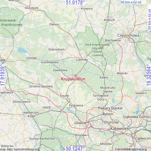
Krupski Młyn GPS coordinates[2]
50° 34' 24.132" North, 18° 37' 21.036" East
| Map corner | latitude | longitude |
|---|---|---|
| Upper-left | 51.0178°, | 17.91939° |
| Center: | 50.57337°, | 18.62251° |
| Lower-right: | 50.1247°, | 19.32564° |
| Map W x H: | 99.3×99.3 km | = 61.7×61.7mi |
| max Lat: | 54.83135° ⇑65.9% North |
| Krupski Młyn: | 50.57337° |
| min Lat: | ⇓34.1% South 49.21328° |
| min Long | Krupski Młyn | max Long |
| 14.20249° | 18.62251° | 24.03723° |
| W 33.8%⇐ | ⇒66.2% E |
Elevation
Elevation of Krupski Młyn is 232 m = 761 ft, and this is 40.6 m = 133 ft above average elevation for this country.
| Max E: |
974 m = 3196 ft | 29.1% |
| Krupski Młyn | 232 m 761 ft | |
| Avg. | 191.4 m = 628 ft | |
Min E: |
-3 m = -10 ft | 70.9% |
See also: Poland elevation on elevation.city.
Geographical zone
Krupski Młyn is located in North temperate zone (between Tropic of Cancer and the Arctic Circle). Distance of this North polar circle is 1777.9 km =1104.7 mi to North.| Distance of | km | miles | from Krupski Młyn |
|---|---|---|---|
| North Pole | 4383.8 | 2724 | to North |
| Arctic Circle | 1777.9 | 1104.7 | to North |
| Tropic Cancer | 3017.3 | 1874.9 | to South |
| Equator | 5623.2 | 3494.1 | to South |


Nearby cities:
15 places around Krupski Młyn: (largest is in red/bold)
• Gwoździany
17.8 km =11.1 mi,  338°
338°
• Jemielnica
17.5 km =10.9 mi,  259°
259°
• Kalety
19.1 km =11.9 mi,  93°
93°
• Kochanowice
17.2 km =10.7 mi,  31°
31°
• Kolonowskie
19 km =11.8 mi,  297°
297°
• Koszęcin
16.9 km =10.5 mi,  66°
66°
• Lubliniec
11.5 km =7.1 mi,  22°
22°
• Pawonków
13.8 km =8.6 mi,  347°
347°
• Pyskowice
19.3 km =12 mi,  177°
177°
• Toszek
15 km =9.3 mi,  208°
208°
• Tworóg
8.1 km =5 mi,  125°
125°
• Wielowieś
7.1 km =4.4 mi, 183°
• Zawadzkie
10.3 km =6.4 mi,  289°
289°
• Zbrosławice
19.8 km =12.3 mi,  151°
151°
• Łaziska
18.2 km =11.3 mi,  274°
274°
Sources, notices
• [Note1] Compared only with cities in Poland existing in our database
• [Src1] Map data: © OpenStreetMap contributors (CC-BY-SA)
• [Src2] Other city data from geonames.org with taken over terms of usage.
• [Src3] Geographical zone / Annual Mean Temperature by Robert A. Rohde @ Wikipedia
