Wielowieś geodata
Wielowieś (Silesia) is a populated place; located in Poland in Europe/Warsaw (GMT+2) time zone. With population of 1,811 people, there are 1603 cities with bigger population in this country. Compared to other cities in Poland, 67.1% of cities are located further ↑North; 66.3% of cities are located further →East and 79.2% of cities have lower elevation than Wielowieś. Note1


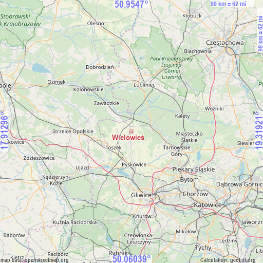
Wielowieś GPS coordinates[2]
50° 30' 34.776" North, 18° 36' 57.888" East
| Map corner | latitude | longitude |
|---|---|---|
| Upper-left | 50.9547°, | 17.91296° |
| Center: | 50.50966°, | 18.61608° |
| Lower-right: | 50.06039°, | 19.31921° |
| Map W x H: | 99.4×99.4 km | = 61.8×61.8mi |
| max Lat: | 54.83135° ⇑67.1% North |
| Wielowieś: | 50.50966° |
| min Lat: | ⇓32.9% South 49.21328° |
| min Long | Wielowieś | max Long |
| 14.20249° | 18.61608° | 24.03723° |
| W 33.7%⇐ | ⇒66.3% E |
Elevation
Elevation of Wielowieś is 262 m = 860 ft, and this is 70.6 m = 232 ft above average elevation for this country.
| Max E: |
974 m = 3196 ft | 20.8% |
| Wielowieś | 262 m 860 ft | |
| Avg. | 191.4 m = 628 ft | |
Min E: |
-3 m = -10 ft | 79.2% |
See also: Poland elevation on elevation.city.
Geographical zone
Wielowieś is located in North temperate zone (between Tropic of Cancer and the Arctic Circle). Distance of this North polar circle is 1785 km =1109.1 mi to North.| Distance of | km | miles | from Wielowieś |
|---|---|---|---|
| North Pole | 4390.9 | 2728.4 | to North |
| Arctic Circle | 1785 | 1109.1 | to North |
| Tropic Cancer | 3010.2 | 1870.5 | to South |
| Equator | 5616.1 | 3489.7 | to South |


Nearby cities:
15 places around Wielowieś: (largest is in red/bold)
• Jemielnica
17.3 km =10.7 mi,  283°
283°
• Kalety
20.4 km =12.7 mi,  73°
73°
• Kleszczów
19.1 km =11.9 mi,  199°
199°
• Koszęcin
21.1 km =13.1 mi,  48°
48°
• Krupski Młyn
7.1 km =4.4 mi,  3°
3°
• Lubliniec
18.4 km =11.4 mi,  15°
15°
• Pawonków
20.8 km =12.9 mi,  353°
353°
• Pyskowice
12.3 km =7.6 mi,  174°
174°
• Tarnowskie Góry
18.8 km =11.7 mi,  112°
112°
• Toszek
9.1 km =5.7 mi,  227°
227°
• Tworóg
7.4 km =4.6 mi, 71°
• Wieszowa
17.2 km =10.7 mi,  143°
143°
• Zawadzkie
14.1 km =8.8 mi,  318°
318°
• Zbrosławice
14.3 km =8.9 mi, 136°
• Łaziska
19.6 km =12.2 mi,  295°
295°
Sources, notices
• [Note1] Compared only with cities in Poland existing in our database
• [Src1] Map data: © OpenStreetMap contributors (CC-BY-SA)
• [Src2] Other city data from geonames.org with taken over terms of usage.
• [Src3] Geographical zone / Annual Mean Temperature by Robert A. Rohde @ Wikipedia
