Środa Śląska geodata
Środa Śląska (Lower Silesia) is a seat of a second-order administrative division; located in Poland in Europe/Warsaw (GMT+2) time zone. With population of 8,912 people, there are 483 cities with bigger population in this country. Compared to other cities in Poland, 50% of cities are located further ↓South; 88.8% of cities are located further →East and 67.4% of cities have higher elevation than Środa Śląska. Note1


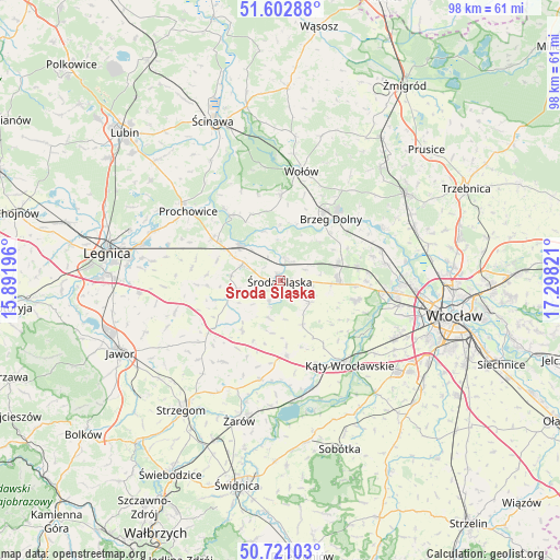
Środa Śląska GPS coordinates[2]
51° 9' 50.616" North, 16° 35' 42.288" East
| Map corner | latitude | longitude |
|---|---|---|
| Upper-left | 51.60288°, | 15.89196° |
| Center: | 51.16406°, | 16.59508° |
| Lower-right: | 50.72103°, | 17.29821° |
| Map W x H: | 98.1×98.1 km | = 61×61mi |
| max Lat: | 54.83135° ⇑50% North |
| Środa Śląska: | 51.16406° |
| min Lat: | ⇓50% South 49.21328° |
| min Long | Środa Śląska | max Long |
| 14.20249° | 16.59508° | 24.03723° |
| W 11.2%⇐ | ⇒88.8% E |
Elevation
Elevation of Środa Śląska is 127 m = 417 ft, and this is 64.4 m = 211 ft below average elevation for this country.
| Max E: |
974 m = 3196 ft | 67.4% |
| Avg. | 191.4 m = 628 ft | |
| Środa Śląska | 127 m = 417 ft | |
Min E: |
-3 m = -10 ft | 32.6% |
See also: Poland elevation on elevation.city.
Geographical zone
Środa Śląska is located in North temperate zone (between Tropic of Cancer and the Arctic Circle). Distance of this North polar circle is 1712.3 km =1064 mi to North.| Distance of | km | miles | from Środa Śląska |
|---|---|---|---|
| North Pole | 4318.2 | 2683.2 | to North |
| Arctic Circle | 1712.3 | 1064 | to North |
| Tropic Cancer | 3083 | 1915.7 | to South |
| Equator | 5688.9 | 3534.9 | to South |


Nearby cities:
15 places around Środa Śląska: (largest is in red/bold)
• Brzeg Dolny
14.4 km =8.9 mi,  33°
33°
• Ciechów
4 km =2.5 mi,  208°
208°
• Jarnołtów-Jerzmanowo
19.5 km =12.1 mi,  104°
104°
• Kostomłoty
13.2 km =8.2 mi,  175°
175°
• Kąty Wrocławskie
19.1 km =11.9 mi,  140°
140°
• Leśnica-Ratyń-Pustki
17.8 km =11.1 mi, 97°
• Lutynia
13.6 km =8.5 mi, 103°
• Malczyce
9.4 km =5.8 mi,  311°
311°
• Małkowice
18.6 km =11.6 mi,  121°
121°
• Miękinia
10.2 km =6.3 mi,  74°
74°
• Mrozów
13.7 km =8.5 mi,  78°
78°
• Szczepanów
3.9 km =2.4 mi,  16°
16°
• Udanin
17.2 km =10.7 mi, 214°
• Wołów
19.5 km =12.1 mi,  10°
10°
• Wądroże Wielkie
19.1 km =11.9 mi,  254°
254°
Sources, notices
• [Note1] Compared only with cities in Poland existing in our database
• [Src1] Map data: © OpenStreetMap contributors (CC-BY-SA)
• [Src2] Other city data from geonames.org with taken over terms of usage.
• [Src3] Geographical zone / Annual Mean Temperature by Robert A. Rohde @ Wikipedia
