Szczepanów geodata
Szczepanów (Lower Silesia) is a populated place; located in Poland in Europe/Warsaw (GMT+2) time zone. With population of 1,700 people, there are 1678 cities with bigger population in this country. Compared to other cities in Poland, 50.9% of cities are located further ↓South; 88.7% of cities are located further →East and 76.9% of cities have higher elevation than Szczepanów. Note1


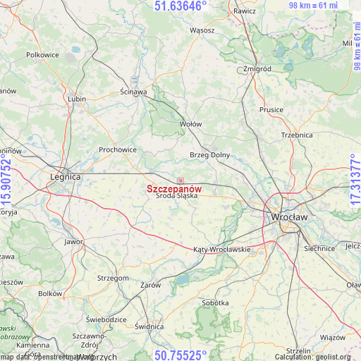
Szczepanów GPS coordinates[2]
51° 11' 52.656" North, 16° 36' 38.304" East
| Map corner | latitude | longitude |
|---|---|---|
| Upper-left | 51.63646°, | 15.90752° |
| Center: | 51.19796°, | 16.61064° |
| Lower-right: | 50.75525°, | 17.31377° |
| Map W x H: | 98×98 km | = 60.9×60.9mi |
| max Lat: | 54.83135° ⇑49.1% North |
| Szczepanów: | 51.19796° |
| min Lat: | ⇓50.9% South 49.21328° |
| min Long | Szczepanów | max Long |
| 14.20249° | 16.61064° | 24.03723° |
| W 11.3%⇐ | ⇒88.7% E |
Elevation
Elevation of Szczepanów is 106 m = 348 ft, and this is 85.4 m = 280 ft below average elevation for this country.
| Max E: |
974 m = 3196 ft | 76.9% |
| Avg. | 191.4 m = 628 ft | |
| Szczepanów | 106 m = 348 ft | |
Min E: |
-3 m = -10 ft | 23.1% |
See also: Poland elevation on elevation.city.
Geographical zone
Szczepanów is located in North temperate zone (between Tropic of Cancer and the Arctic Circle). Distance of this North polar circle is 1708.5 km =1061.6 mi to North.| Distance of | km | miles | from Szczepanów |
|---|---|---|---|
| North Pole | 4314.4 | 2680.8 | to North |
| Arctic Circle | 1708.5 | 1061.6 | to North |
| Tropic Cancer | 3086.8 | 1918 | to South |
| Equator | 5692.7 | 3537.3 | to South |


Nearby cities:
15 places around Szczepanów: (largest is in red/bold)
• Brzeg Dolny
10.8 km =6.7 mi,  39°
39°
• Ciechów
7.9 km =4.9 mi,  202°
202°
• Jarnołtów-Jerzmanowo
19.7 km =12.2 mi,  115°
115°
• Kostomłoty
16.9 km =10.5 mi,  180°
180°
• Leśnica-Ratyń-Pustki
17.7 km =11 mi,  110°
110°
• Lutynia
13.9 km =8.6 mi, 119°
• Malczyce
8.5 km =5.3 mi,  287°
287°
• Marszowice
19.3 km =12 mi,  98°
98°
• Małkowice
20 km =12.4 mi,  132°
132°
• Miękinia
8.8 km =5.5 mi, 96°
• Mrozów
12.4 km =7.7 mi, 95°
• Prochowice
19 km =11.8 mi,  296°
296°
• Uraz
17.7 km =11 mi,  71°
71°
• Wołów
15.6 km =9.7 mi,  8°
8°
• Środa Śląska
3.9 km =2.4 mi, 196°
Sources, notices
• [Note1] Compared only with cities in Poland existing in our database
• [Src1] Map data: © OpenStreetMap contributors (CC-BY-SA)
• [Src2] Other city data from geonames.org with taken over terms of usage.
• [Src3] Geographical zone / Annual Mean Temperature by Robert A. Rohde @ Wikipedia
