Malczyce geodata
Malczyce (Lower Silesia) is a populated place; located in Poland in Europe/Warsaw (GMT+2) time zone. With population of 3,100 people, there are 1018 cities with bigger population in this country. Compared to other cities in Poland, 51.3% of cities are located further ↓South; 89.6% of cities are located further →East and 75.8% of cities have higher elevation than Malczyce. Note1


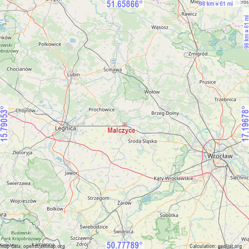
Malczyce GPS coordinates[2]
51° 13' 13.368" North, 16° 29' 37.14" East
| Map corner | latitude | longitude |
|---|---|---|
| Upper-left | 51.65866°, | 15.79053° |
| Center: | 51.22038°, | 16.49365° |
| Lower-right: | 50.77789°, | 17.19678° |
| Map W x H: | 97.9×97.9 km | = 60.8×60.8mi |
| max Lat: | 54.83135° ⇑48.7% North |
| Malczyce: | 51.22038° |
| min Lat: | ⇓51.3% South 49.21328° |
| min Long | Malczyce | max Long |
| 14.20249° | 16.49365° | 24.03723° |
| W 10.4%⇐ | ⇒89.6% E |
Elevation
Elevation of Malczyce is 109 m = 358 ft, and this is 82.4 m = 270 ft below average elevation for this country.
| Max E: |
974 m = 3196 ft | 75.8% |
| Avg. | 191.4 m = 628 ft | |
| Malczyce | 109 m = 358 ft | |
Min E: |
-3 m = -10 ft | 24.2% |
See also: Poland elevation on elevation.city.
Geographical zone
Malczyce is located in North temperate zone (between Tropic of Cancer and the Arctic Circle). Distance of this North polar circle is 1706 km =1060.1 mi to North.| Distance of | km | miles | from Malczyce |
|---|---|---|---|
| North Pole | 4311.9 | 2679.3 | to North |
| Arctic Circle | 1706 | 1060.1 | to North |
| Tropic Cancer | 3089.3 | 1919.6 | to South |
| Equator | 5695.2 | 3538.8 | to South |


Nearby cities:
15 places around Malczyce: (largest is in red/bold)
• Brzeg Dolny
16 km =9.9 mi,  68°
68°
• Ciechów
11.1 km =6.9 mi,  152°
152°
• Kostomłoty
21 km =13 mi,  157°
157°
• Kunice
17.1 km =10.6 mi,  270°
270°
• Legnickie Pole
19.5 km =12.1 mi,  244°
244°
• Lisowice
12.7 km =7.9 mi,  306°
306°
• Mierczyce
18.9 km =11.7 mi,  221°
221°
• Miękinia
17.2 km =10.7 mi,  101°
101°
• Mrozów
20.8 km =12.9 mi, 99°
• Prochowice
10.7 km =6.6 mi,  303°
303°
• Szczepanów
8.5 km =5.3 mi,  107°
107°
• Udanin
20.5 km =12.7 mi,  187°
187°
• Wołów
16.6 km =10.3 mi,  39°
39°
• Wądroże Wielkie
16.1 km =10 mi, 224°
• Środa Śląska
9.4 km =5.8 mi,  131°
131°
Sources, notices
• [Note1] Compared only with cities in Poland existing in our database
• [Src1] Map data: © OpenStreetMap contributors (CC-BY-SA)
• [Src2] Other city data from geonames.org with taken over terms of usage.
• [Src3] Geographical zone / Annual Mean Temperature by Robert A. Rohde @ Wikipedia
