Wołczyn geodata
Wołczyn (Opole Voivodeship) is a seat of a third-order administrative division; located in Poland in Europe/Warsaw (GMT+2) time zone. With population of 6,221 people, there are 586 cities with bigger population in this country. Compared to other cities in Poland, 55% of cities are located further ↑North; 74.7% of cities are located further →East and 51.3% of cities have higher elevation than Wołczyn. Note1


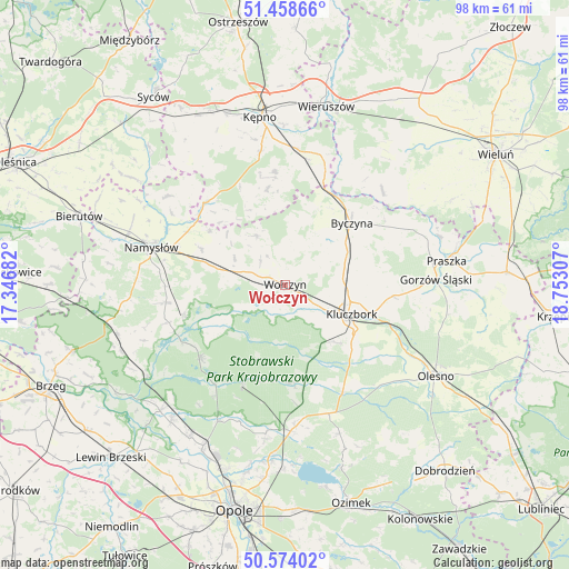
Wołczyn GPS coordinates[2]
51° 1' 6.42" North, 18° 2' 59.784" East
| Map corner | latitude | longitude |
|---|---|---|
| Upper-left | 51.45866°, | 17.34682° |
| Center: | 51.01845°, | 18.04994° |
| Lower-right: | 50.57402°, | 18.75307° |
| Map W x H: | 98.4×98.4 km | = 61.1×61.1mi |
| max Lat: | 54.83135° ⇑55% North |
| Wołczyn: | 51.01845° |
| min Lat: | ⇓45% South 49.21328° |
| min Long | Wołczyn | max Long |
| 14.20249° | 18.04994° | 24.03723° |
| W 25.3%⇐ | ⇒74.7% E |
Elevation
Elevation of Wołczyn is 169 m = 554 ft, and this is 22.4 m = 73 ft below average elevation for this country.
| Max E: |
974 m = 3196 ft | 51.3% |
| Avg. | 191.4 m = 628 ft | |
| Wołczyn | 169 m = 554 ft | |
Min E: |
-3 m = -10 ft | 48.7% |
See also: Poland elevation on elevation.city.
Geographical zone
Wołczyn is located in North temperate zone (between Tropic of Cancer and the Arctic Circle). Distance of this North polar circle is 1728.5 km =1074 mi to North.| Distance of | km | miles | from Wołczyn |
|---|---|---|---|
| North Pole | 4334.3 | 2693.2 | to North |
| Arctic Circle | 1728.5 | 1074 | to North |
| Tropic Cancer | 3066.8 | 1905.6 | to South |
| Equator | 5672.7 | 3524.9 | to South |


Nearby cities:
15 places around Wołczyn: (largest is in red/bold)
• Borkowice
11.5 km =7.1 mi,  138°
138°
• Byczyna
15.6 km =9.7 mi,  47°
47°
• Domaradz
15.1 km =9.4 mi,  238°
238°
• Domaszowice
11.6 km =7.2 mi,  283°
283°
• Kluczbork
12.8 km =8 mi,  113°
113°
• Lasowice Małe
19.2 km =11.9 mi,  131°
131°
• Lasowice Wielkie
20.6 km =12.8 mi, 143°
• Murów
18.8 km =11.7 mi,  202°
202°
• Pokój
19.7 km =12.2 mi,  229°
229°
• Rychtal
19.8 km =12.3 mi,  315°
315°
• Siemianice
19.1 km =11.9 mi,  19°
19°
• Strzelce
14.3 km =8.9 mi,  291°
291°
• Trzcinica
16.8 km =10.4 mi,  349°
349°
• Wielki Buczek
14.1 km =8.8 mi,  335°
335°
• Świerczów
21.4 km =13.3 mi,  252°
252°
Sources, notices
• [Note1] Compared only with cities in Poland existing in our database
• [Src1] Map data: © OpenStreetMap contributors (CC-BY-SA)
• [Src2] Other city data from geonames.org with taken over terms of usage.
• [Src3] Geographical zone / Annual Mean Temperature by Robert A. Rohde @ Wikipedia
