Kluczbork geodata
Kluczbork (Opole Voivodeship) is a seat of a second-order administrative division; located in Poland in Europe/Warsaw (GMT+2) time zone. With population of 25,978 people, there are 188 cities with bigger population in this country. Compared to other cities in Poland, 55.8% of cities are located further ↑North; 72.3% of cities are located further →East and 55% of cities have lower elevation than Kluczbork. Note1
Administrative division(s):
- Level 1: Opole Voivodeship
- Level 2: Powiat kluczborski
- Level 3: Kluczbork


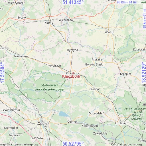
Kluczbork GPS coordinates[2]
50° 58' 22.116" North, 18° 13' 5.376" East
| Map corner | latitude | longitude |
|---|---|---|
| Upper-left | 51.41345°, | 17.51504° |
| Center: | 50.97281°, | 18.21816° |
| Lower-right: | 50.52795°, | 18.92129° |
| Map W x H: | 98.5×98.5 km | = 61.2×61.2mi |
| max Lat: | 54.83135° ⇑55.8% North |
| Kluczbork: | 50.97281° |
| min Lat: | ⇓44.2% South 49.21328° |
| min Long | Kluczbork | max Long |
| 14.20249° | 18.21816° | 24.03723° |
| W 27.7%⇐ | ⇒72.3% E |
Elevation
Elevation of Kluczbork is 185 m = 607 ft, and this is 6.4 m = 21 ft below average elevation for this country.
| Max E: |
974 m = 3196 ft | 45% |
| Avg. | 191.4 m = 628 ft | |
| Kluczbork | 185 m = 607 ft | |
Min E: |
-3 m = -10 ft | 55% |
See also: Poland elevation on elevation.city.
Geographical zone
Kluczbork is located in North temperate zone (between Tropic of Cancer and the Arctic Circle). Distance of this North polar circle is 1733.5 km =1077.1 mi to North.| Distance of | km | miles | from Kluczbork |
|---|---|---|---|
| North Pole | 4339.4 | 2696.4 | to North |
| Arctic Circle | 1733.5 | 1077.1 | to North |
| Tropic Cancer | 3061.7 | 1902.5 | to South |
| Equator | 5667.6 | 3521.7 | to South |


Nearby cities:
15 places around Kluczbork: (largest is in red/bold)
• Bierdzany
17.7 km =11 mi,  193°
193°
• Borkowice
5.5 km =3.4 mi,  230°
230°
• Byczyna
15.7 km =9.8 mi,  358°
358°
• Dzietrzkowice
21.9 km =13.6 mi,  19°
19°
• Gorzów Śląski
15.6 km =9.7 mi,  66°
66°
• Kowale
21.5 km =13.4 mi,  56°
56°
• Lasowice Małe
8 km =5 mi,  161°
161°
• Lasowice Wielkie
11.5 km =7.1 mi,  176°
176°
• Olesno
17.8 km =11.1 mi,  126°
126°
• Praszka
18.7 km =11.6 mi, 61°
• Przedmość
20.3 km =12.6 mi,  48°
48°
• Wojciechów
14.8 km =9.2 mi,  124°
124°
• Wołczyn
12.8 km =8 mi,  293°
293°
• Zdziechowice
18.2 km =11.3 mi,  41°
41°
• Łubnice
21.9 km =13.6 mi,  13°
13°
Sources, notices
• [Note1] Compared only with cities in Poland existing in our database
• [Src1] Map data: © OpenStreetMap contributors (CC-BY-SA)
• [Src2] Other city data from geonames.org with taken over terms of usage.
• [Src3] Geographical zone / Annual Mean Temperature by Robert A. Rohde @ Wikipedia
