Brdów geodata
Brdów (Greater Poland) is a populated place; located in Poland in Europe/Warsaw (GMT+2) time zone. With population of 1,050 people, there are 2405 cities with bigger population in this country. Compared to other cities in Poland, 73.7% of cities are located further ↓South; 64.6% of cities are located further →East and 73.1% of cities have higher elevation than Brdów. Note1


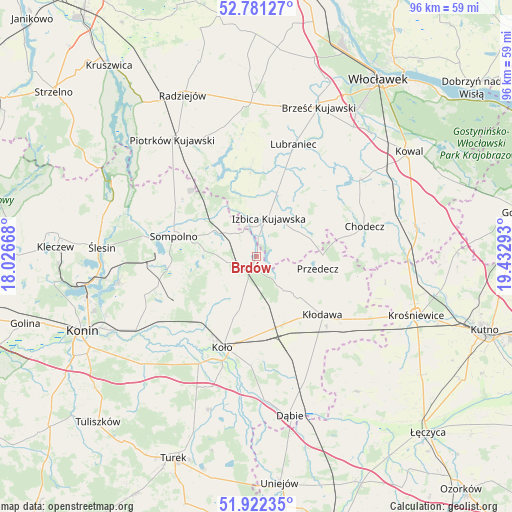
Brdów GPS coordinates[2]
52° 21' 14.04" North, 18° 43' 47.28" East
| Map corner | latitude | longitude |
|---|---|---|
| Upper-left | 52.78127°, | 18.02668° |
| Center: | 52.3539°, | 18.7298° |
| Lower-right: | 51.92235°, | 19.43293° |
| Map W x H: | 95.5×95.5 km | = 59.3×59.3mi |
| max Lat: | 54.83135° ⇑26.3% North |
| Brdów: | 52.3539° |
| min Lat: | ⇓73.7% South 49.21328° |
| min Long | Brdów | max Long |
| 14.20249° | 18.7298° | 24.03723° |
| W 35.4%⇐ | ⇒64.6% E |
Elevation
Elevation of Brdów is 115 m = 377 ft, and this is 76.4 m = 251 ft below average elevation for this country.
| Max E: |
974 m = 3196 ft | 73.1% |
| Avg. | 191.4 m = 628 ft | |
| Brdów | 115 m = 377 ft | |
Min E: |
-3 m = -10 ft | 26.9% |
See also: Poland elevation on elevation.city.
Geographical zone
Brdów is located in North temperate zone (between Tropic of Cancer and the Arctic Circle). Distance of this North polar circle is 1580 km =981.8 mi to North.| Distance of | km | miles | from Brdów |
|---|---|---|---|
| North Pole | 4185.9 | 2601 | to North |
| Arctic Circle | 1580 | 981.8 | to North |
| Tropic Cancer | 3215.3 | 1997.9 | to South |
| Equator | 5821.2 | 3617.1 | to South |


Nearby cities:
15 places around Brdów: (largest is in red/bold)
• Babiak
4.4 km =2.7 mi,  257°
257°
• Boniewo
16.5 km =10.3 mi,  41°
41°
• Chodecz
21 km =13 mi,  74°
74°
• Grzegorzew
16.9 km =10.5 mi,  179°
179°
• Izbica Kujawska
7.8 km =4.8 mi,  16°
16°
• Koło
18.2 km =11.3 mi,  199°
199°
• Kłodawa
16.7 km =10.4 mi,  131°
131°
• Lubraniec
22 km =13.7 mi, 18°
• Olszówka
20.3 km =12.6 mi,  153°
153°
• Osiek Mały
12.2 km =7.6 mi,  225°
225°
• Police
17.7 km =11 mi,  274°
274°
• Przedecz
11.7 km =7.3 mi,  100°
100°
• Sompolno
15.9 km =9.9 mi,  283°
283°
• Topólka
16.6 km =10.3 mi,  355°
355°
• Wierzbinek
17.7 km =11 mi,  302°
302°
Sources, notices
• [Note1] Compared only with cities in Poland existing in our database
• [Src1] Map data: © OpenStreetMap contributors (CC-BY-SA)
• [Src2] Other city data from geonames.org with taken over terms of usage.
• [Src3] Geographical zone / Annual Mean Temperature by Robert A. Rohde @ Wikipedia
