Izbica Kujawska geodata
Izbica Kujawska (Kujawsko-Pomorskie) is a seat of a third-order administrative division; located in Poland in Europe/Warsaw (GMT+2) time zone. With population of 2,771 people, there are 1137 cities with bigger population in this country. Compared to other cities in Poland, 75.1% of cities are located further ↓South; 64% of cities are located further →East and 71.6% of cities have higher elevation than Izbica Kujawska. Note1
Administrative division(s):
- Level 1: Kujawsko-Pomorskie
- Level 2: Powiat włocławski
- Level 3: Izbica Kujawska


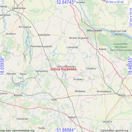
Izbica Kujawska GPS coordinates[2]
52° 25' 14.628" North, 18° 45' 45.72" East
| Map corner | latitude | longitude |
|---|---|---|
| Upper-left | 52.84745°, | 18.05958° |
| Center: | 52.42073°, | 18.7627° |
| Lower-right: | 51.98984°, | 19.46583° |
| Map W x H: | 95.4×95.4 km | = 59.3×59.3mi |
| max Lat: | 54.83135° ⇑24.9% North |
| Izbica Kujawska: | 52.42073° |
| min Lat: | ⇓75.1% South 49.21328° |
| min Long | Izbica Kujawska | max Long |
| 14.20249° | 18.7627° | 24.03723° |
| W 36%⇐ | ⇒64% E |
Elevation
Elevation of Izbica Kujawska is 118 m = 387 ft, and this is 73.4 m = 241 ft below average elevation for this country.
| Max E: |
974 m = 3196 ft | 71.6% |
| Avg. | 191.4 m = 628 ft | |
| Izbica Kujawska | 118 m = 387 ft | |
Min E: |
-3 m = -10 ft | 28.4% |
See also: Poland elevation on elevation.city.
Geographical zone
Izbica Kujawska is located in North temperate zone (between Tropic of Cancer and the Arctic Circle). Distance of this North polar circle is 1572.5 km =977.1 mi to North.| Distance of | km | miles | from Izbica Kujawska |
|---|---|---|---|
| North Pole | 4178.4 | 2596.3 | to North |
| Arctic Circle | 1572.5 | 977.1 | to North |
| Tropic Cancer | 3222.7 | 2002.5 | to South |
| Equator | 5828.6 | 3621.7 | to South |


Nearby cities:
15 places around Izbica Kujawska: (largest is in red/bold)
• Babiak
10.6 km =6.6 mi,  217°
217°
• Boniewo
10 km =6.2 mi,  60°
60°
• Brdów
7.8 km =4.8 mi,  196°
196°
• Brześć Kujawski
22.6 km =14 mi,  24°
24°
• Bytoń
19 km =11.8 mi,  323°
323°
• Choceń
18.5 km =11.5 mi,  66°
66°
• Chodecz
18 km =11.2 mi,  95°
95°
• Kłodawa
21.1 km =13.1 mi,  151°
151°
• Lubraniec
14.3 km =8.9 mi, 19°
• Osiek Mały
19.4 km =12.1 mi,  214°
214°
• Police
20.8 km =12.9 mi,  252°
252°
• Przedecz
13.3 km =8.3 mi,  136°
136°
• Sompolno
18 km =11.2 mi,  258°
258°
• Topólka
9.8 km =6.1 mi,  339°
339°
• Wierzbinek
17.2 km =10.7 mi,  277°
277°
Sources, notices
• [Note1] Compared only with cities in Poland existing in our database
• [Src1] Map data: © OpenStreetMap contributors (CC-BY-SA)
• [Src2] Other city data from geonames.org with taken over terms of usage.
• [Src3] Geographical zone / Annual Mean Temperature by Robert A. Rohde @ Wikipedia
