Wąsosz geodata
Wąsosz (Lower Silesia) is a populated place; located in Poland in Europe/Warsaw (GMT+2) time zone. With population of 2,789 people, there are 1135 cities with bigger population in this country. Compared to other cities in Poland, 57.3% of cities are located further ↓South; 88.1% of cities are located further →East and 86.1% of cities have higher elevation than Wąsosz. Note1


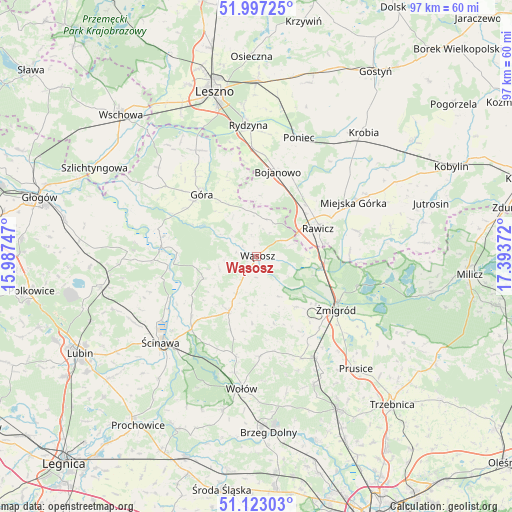
Wąsosz GPS coordinates[2]
51° 33' 44.064" North, 16° 41' 26.124" East
| Map corner | latitude | longitude |
|---|---|---|
| Upper-left | 51.99725°, | 15.98747° |
| Center: | 51.56224°, | 16.69059° |
| Lower-right: | 51.12303°, | 17.39372° |
| Map W x H: | 97.2×97.2 km | = 60.4×60.4mi |
| max Lat: | 54.83135° ⇑42.7% North |
| Wąsosz: | 51.56224° |
| min Lat: | ⇓57.3% South 49.21328° |
| min Long | Wąsosz | max Long |
| 14.20249° | 16.69059° | 24.03723° |
| W 11.9%⇐ | ⇒88.1% E |
Elevation
Elevation of Wąsosz is 87 m = 285 ft, and this is 104.4 m = 343 ft below average elevation for this country.
| Max E: |
974 m = 3196 ft | 86.1% |
| Avg. | 191.4 m = 628 ft | |
| Wąsosz | 87 m = 285 ft | |
Min E: |
-3 m = -10 ft | 13.9% |
See also: Poland elevation on elevation.city.
Geographical zone
Wąsosz is located in North temperate zone (between Tropic of Cancer and the Arctic Circle). Distance of this North polar circle is 1668 km =1036.4 mi to North.| Distance of | km | miles | from Wąsosz |
|---|---|---|---|
| North Pole | 4273.9 | 2655.7 | to North |
| Arctic Circle | 1668 | 1036.4 | to North |
| Tropic Cancer | 3127.3 | 1943.2 | to South |
| Equator | 5733.2 | 3562.4 | to South |


Nearby cities:
15 places around Wąsosz: (largest is in red/bold)
• Bojanowo
16.6 km =10.3 mi,  13°
13°
• Chojno
23.1 km =14.4 mi,  72°
72°
• Chróścina
22.7 km =14.1 mi,  332°
332°
• Dębno Polskie
13.3 km =8.3 mi,  78°
78°
• Golina Wielka
16.6 km =10.3 mi,  22°
22°
• Góra
15.8 km =9.8 mi,  317°
317°
• Jemielno
11 km =6.8 mi,  247°
247°
• Miejska Górka
21.2 km =13.2 mi,  60°
60°
• Poniec
23.8 km =14.8 mi, 20°
• Rawicz
12.7 km =7.9 mi, 65°
• Szymanowo
14.8 km =9.2 mi, 71°
• Słupia Kapitulna
19.2 km =11.9 mi, 74°
• Wińsko
11.5 km =7.1 mi,  207°
207°
• Ścinawa
24.5 km =15.2 mi,  228°
228°
• Żmigród
18.3 km =11.4 mi,  125°
125°
Sources, notices
• [Note1] Compared only with cities in Poland existing in our database
• [Src1] Map data: © OpenStreetMap contributors (CC-BY-SA)
• [Src2] Other city data from geonames.org with taken over terms of usage.
• [Src3] Geographical zone / Annual Mean Temperature by Robert A. Rohde @ Wikipedia
