Ciechów geodata
Ciechów (Lower Silesia) is a populated place; located in Poland in Europe/Warsaw (GMT+2) time zone. With population of 1,500 people, there are 1837 cities with bigger population in this country. Compared to other cities in Poland, 51.5% of cities are located further ↑North; 89.1% of cities are located further →East and 62.1% of cities have higher elevation than Ciechów. Note1


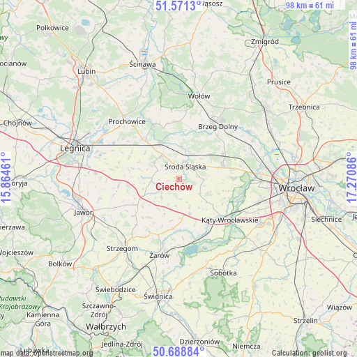
Ciechów GPS coordinates[2]
51° 7' 55.848" North, 16° 34' 3.828" East
| Map corner | latitude | longitude |
|---|---|---|
| Upper-left | 51.5713°, | 15.86461° |
| Center: | 51.13218°, | 16.56773° |
| Lower-right: | 50.68884°, | 17.27086° |
| Map W x H: | 98.1×98.1 km | = 61×61mi |
| max Lat: | 54.83135° ⇑51.5% North |
| Ciechów: | 51.13218° |
| min Lat: | ⇓48.5% South 49.21328° |
| min Long | Ciechów | max Long |
| 14.20249° | 16.56773° | 24.03723° |
| W 10.9%⇐ | ⇒89.1% E |
Elevation
Elevation of Ciechów is 142 m = 466 ft, and this is 49.4 m = 162 ft below average elevation for this country.
| Max E: |
974 m = 3196 ft | 62.1% |
| Avg. | 191.4 m = 628 ft | |
| Ciechów | 142 m = 466 ft | |
Min E: |
-3 m = -10 ft | 37.9% |
See also: Poland elevation on elevation.city.
Geographical zone
Ciechów is located in North temperate zone (between Tropic of Cancer and the Arctic Circle). Distance of this North polar circle is 1715.8 km =1066.1 mi to North.| Distance of | km | miles | from Ciechów |
|---|---|---|---|
| North Pole | 4321.7 | 2685.4 | to North |
| Arctic Circle | 1715.8 | 1066.1 | to North |
| Tropic Cancer | 3079.4 | 1913.4 | to South |
| Equator | 5685.4 | 3532.7 | to South |


Nearby cities:
15 places around Ciechów: (largest is in red/bold)
• Brzeg Dolny
18.5 km =11.5 mi,  31°
31°
• Konary
15.9 km =9.9 mi,  230°
230°
• Kostomłoty
10.1 km =6.3 mi,  162°
162°
• Kąty Wrocławskie
17.9 km =11.1 mi,  128°
128°
• Leśnica-Ratyń-Pustki
19.6 km =12.2 mi,  86°
86°
• Lutynia
15.1 km =9.4 mi, 88°
• Malczyce
11.1 km =6.9 mi,  332°
332°
• Małkowice
18.8 km =11.7 mi,  108°
108°
• Mierczyce
18.3 km =11.4 mi,  256°
256°
• Miękinia
13.3 km =8.3 mi,  61°
61°
• Mrozów
16.6 km =10.3 mi,  67°
67°
• Szczepanów
7.9 km =4.9 mi,  22°
22°
• Udanin
13.2 km =8.2 mi,  216°
216°
• Wądroże Wielkie
16.5 km =10.3 mi, 264°
• Środa Śląska
4 km =2.5 mi, 28°
Sources, notices
• [Note1] Compared only with cities in Poland existing in our database
• [Src1] Map data: © OpenStreetMap contributors (CC-BY-SA)
• [Src2] Other city data from geonames.org with taken over terms of usage.
• [Src3] Geographical zone / Annual Mean Temperature by Robert A. Rohde @ Wikipedia
