Stanowice geodata
Stanowice (Lower Silesia) is a populated place; located in Poland in Europe/Warsaw (GMT+2) time zone. With population of 1,200 people, there are 2164 cities with bigger population in this country. Compared to other cities in Poland, 56.8% of cities are located further ↑North; 90.3% of cities are located further →East and 68.4% of cities have lower elevation than Stanowice. Note1


Stanowice GPS coordinates[2]
50° 55' 51.816" North, 16° 22' 27.336" East
| Map corner | latitude | longitude |
|---|---|---|
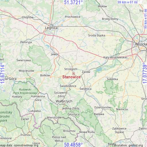
| Upper-left | 51.3721°, | 15.67114° |
| Center: | 50.93106°, | 16.37426° |
| Lower-right: | 50.4858°, | 17.07739° |
| Map W x H: | 98.5×98.5 km | = 61.2×61.2mi |
| max Lat: | 54.83135° ⇑56.8% North |
| Stanowice: | 50.93106° |
| min Lat: | ⇓43.2% South 49.21328° |
| min Long | Stanowice | max Long |
| 14.20249° | 16.37426° | 24.03723° |
| W 9.7%⇐ | ⇒90.3% E |
Elevation
Elevation of Stanowice is 224 m = 735 ft, and this is 32.6 m = 107 ft above average elevation for this country.
| Max E: |
974 m = 3196 ft | 31.6% |
| Stanowice | 224 m 735 ft | |
| Avg. | 191.4 m = 628 ft | |
Min E: |
-3 m = -10 ft | 68.4% |
See also: Poland elevation on elevation.city.
Geographical zone
Stanowice is located in North temperate zone (between Tropic of Cancer and the Arctic Circle). Distance of this North polar circle is 1738.2 km =1080.1 mi to North.| Distance of | km | miles | from Stanowice |
|---|---|---|---|
| North Pole | 4344.1 | 2699.3 | to North |
| Arctic Circle | 1738.2 | 1080.1 | to North |
| Tropic Cancer | 3057.1 | 1899.6 | to South |
| Equator | 5663 | 3518.8 | to South |


Nearby cities:
15 places around Stanowice: (largest is in red/bold)
• Dobromierz
9.5 km =5.9 mi,  256°
256°
• Dziećmorowice
18 km =11.2 mi,  184°
184°
• Jawor
18.4 km =11.4 mi,  316°
316°
• Jaworzyna Śląska
4.5 km =2.8 mi,  115°
115°
• Konary
12.3 km =7.6 mi,  5°
5°
• Marcinowice
15.8 km =9.8 mi,  111°
111°
• Mierczyce
18.5 km =11.5 mi,  346°
346°
• Paszowice
17.9 km =11.1 mi,  299°
299°
• Stare Bogaczowice
15.7 km =9.8 mi,  233°
233°
• Strzegom
3.9 km =2.4 mi,  334°
334°
• Szczawno-Zdrój
16.4 km =10.2 mi,  210°
210°
• Udanin
13.1 km =8.1 mi,  25°
25°
• Świdnica
12.6 km =7.8 mi,  140°
140°
• Świebodzice
8.8 km =5.5 mi, 205°
• Żarów
8.5 km =5.3 mi,  82°
82°
Sources, notices
• [Note1] Compared only with cities in Poland existing in our database
• [Src1] Map data: © OpenStreetMap contributors (CC-BY-SA)
• [Src2] Other city data from geonames.org with taken over terms of usage.
• [Src3] Geographical zone / Annual Mean Temperature by Robert A. Rohde @ Wikipedia
