Strzegom geodata
Strzegom (Lower Silesia) is a populated place; located in Poland in Europe/Warsaw (GMT+2) time zone. With population of 17,004 people, there are 290 cities with bigger population in this country. Compared to other cities in Poland, 56% of cities are located further ↑North; 90.5% of cities are located further →East and 69.8% of cities have lower elevation than Strzegom. Note1


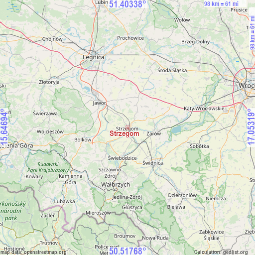
Strzegom GPS coordinates[2]
50° 57' 45.504" North, 16° 21' 0.216" East
| Map corner | latitude | longitude |
|---|---|---|
| Upper-left | 51.40338°, | 15.64694° |
| Center: | 50.96264°, | 16.35006° |
| Lower-right: | 50.51768°, | 17.05319° |
| Map W x H: | 98.5×98.5 km | = 61.2×61.2mi |
| max Lat: | 54.83135° ⇑56% North |
| Strzegom: | 50.96264° |
| min Lat: | ⇓44% South 49.21328° |
| min Long | Strzegom | max Long |
| 14.20249° | 16.35006° | 24.03723° |
| W 9.5%⇐ | ⇒90.5% E |
Elevation
Elevation of Strzegom is 229 m = 751 ft, and this is 37.6 m = 123 ft above average elevation for this country.
| Max E: |
974 m = 3196 ft | 30.2% |
| Strzegom | 229 m 751 ft | |
| Avg. | 191.4 m = 628 ft | |
Min E: |
-3 m = -10 ft | 69.8% |
See also: Poland elevation on elevation.city.
Geographical zone
Strzegom is located in North temperate zone (between Tropic of Cancer and the Arctic Circle). Distance of this North polar circle is 1734.7 km =1077.9 mi to North.| Distance of | km | miles | from Strzegom |
|---|---|---|---|
| North Pole | 4340.5 | 2697.1 | to North |
| Arctic Circle | 1734.7 | 1077.9 | to North |
| Tropic Cancer | 3060.6 | 1901.8 | to South |
| Equator | 5666.5 | 3521 | to South |


Nearby cities:
15 places around Strzegom: (largest is in red/bold)
• Bolków
18 km =11.2 mi,  255°
255°
• Dobromierz
9.5 km =5.9 mi,  233°
233°
• Jawor
14.7 km =9.1 mi,  311°
311°
• Jaworzyna Śląska
8 km =5 mi,  133°
133°
• Konary
9.2 km =5.7 mi,  18°
18°
• Marcinowice
18.8 km =11.7 mi,  119°
119°
• Mierczyce
14.7 km =9.1 mi,  350°
350°
• Paszowice
14.8 km =9.2 mi,  291°
291°
• Stanowice
3.9 km =2.4 mi,  154°
154°
• Stare Bogaczowice
16.9 km =10.5 mi,  220°
220°
• Udanin
11.1 km =6.9 mi,  41°
41°
• Wądroże Wielkie
17.2 km =10.7 mi,  355°
355°
• Świdnica
16.4 km =10.2 mi,  143°
143°
• Świebodzice
11.6 km =7.2 mi,  190°
190°
• Żarów
10.4 km =6.5 mi,  103°
103°
Sources, notices
• [Note1] Compared only with cities in Poland existing in our database
• [Src1] Map data: © OpenStreetMap contributors (CC-BY-SA)
• [Src2] Other city data from geonames.org with taken over terms of usage.
• [Src3] Geographical zone / Annual Mean Temperature by Robert A. Rohde @ Wikipedia
