Żarów geodata
Żarów (Lower Silesia) is a populated place; located in Poland in Europe/Warsaw (GMT+2) time zone. With population of 7,065 people, there are 535 cities with bigger population in this country. Compared to other cities in Poland, 56.6% of cities are located further ↑North; 89.6% of cities are located further →East and 61.9% of cities have lower elevation than Żarów. Note1


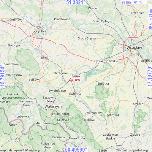
Żarów GPS coordinates[2]
50° 56' 28.176" North, 16° 29' 40.776" East
| Map corner | latitude | longitude |
|---|---|---|
| Upper-left | 51.3821°, | 15.79154° |
| Center: | 50.94116°, | 16.49466° |
| Lower-right: | 50.49599°, | 17.19779° |
| Map W x H: | 98.5×98.5 km | = 61.2×61.2mi |
| max Lat: | 54.83135° ⇑56.6% North |
| Żarów: | 50.94116° |
| min Lat: | ⇓43.4% South 49.21328° |
| min Long | Żarów | max Long |
| 14.20249° | 16.49466° | 24.03723° |
| W 10.4%⇐ | ⇒89.6% E |
Elevation
Elevation of Żarów is 205 m = 673 ft, and this is 13.6 m = 45 ft above average elevation for this country.
| Max E: |
974 m = 3196 ft | 38.1% |
| Żarów | 205 m 673 ft | |
| Avg. | 191.4 m = 628 ft | |
Min E: |
-3 m = -10 ft | 61.9% |
See also: Poland elevation on elevation.city.
Geographical zone
Żarów is located in North temperate zone (between Tropic of Cancer and the Arctic Circle). Distance of this North polar circle is 1737 km =1079.3 mi to North.| Distance of | km | miles | from Żarów |
|---|---|---|---|
| North Pole | 4342.9 | 2698.6 | to North |
| Arctic Circle | 1737 | 1079.3 | to North |
| Tropic Cancer | 3058.2 | 1900.3 | to South |
| Equator | 5664.1 | 3519.5 | to South |


Nearby cities:
15 places around Żarów: (largest is in red/bold)
• Ciechów
21.8 km =13.5 mi,  13°
13°
• Dobromierz
18 km =11.2 mi,  259°
259°
• Dziećmorowice
21.6 km =13.4 mi,  207°
207°
• Jaworzyna Śląska
5.3 km =3.3 mi,  234°
234°
• Konary
13.2 km =8.2 mi,  326°
326°
• Kostomłoty
14.2 km =8.8 mi,  34°
34°
• Kąty Wrocławskie
21.6 km =13.4 mi,  62°
62°
• Marcinowice
9.3 km =5.8 mi,  137°
137°
• Mierczyce
21.1 km =13.1 mi,  323°
323°
• Sobótka
18.1 km =11.2 mi,  104°
104°
• Stanowice
8.5 km =5.3 mi, 262°
• Strzegom
10.4 km =6.5 mi,  283°
283°
• Udanin
11.1 km =6.9 mi,  345°
345°
• Świdnica
10.8 km =6.7 mi,  182°
182°
• Świebodzice
15.2 km =9.4 mi, 233°
Sources, notices
• [Note1] Compared only with cities in Poland existing in our database
• [Src1] Map data: © OpenStreetMap contributors (CC-BY-SA)
• [Src2] Other city data from geonames.org with taken over terms of usage.
• [Src3] Geographical zone / Annual Mean Temperature by Robert A. Rohde @ Wikipedia
