Pamiątkowo geodata
Pamiątkowo (Greater Poland) is a populated place; located in Poland in Europe/Warsaw (GMT+2) time zone. With population of 1,200 people, there are 2164 cities with bigger population in this country. Compared to other cities in Poland, 77.2% of cities are located further ↓South; 88.2% of cities are located further →East and 89.6% of cities have higher elevation than Pamiątkowo. Note1


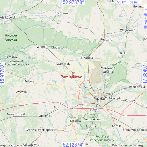
Pamiątkowo GPS coordinates[2]
52° 33' 12.024" North, 16° 40' 51.384" East
| Map corner | latitude | longitude |
|---|---|---|
| Upper-left | 52.97878°, | 15.97782° |
| Center: | 52.55334°, | 16.68094° |
| Lower-right: | 52.12374°, | 17.38407° |
| Map W x H: | 95.1×95.1 km | = 59.1×59.1mi |
| max Lat: | 54.83135° ⇑22.8% North |
| Pamiątkowo: | 52.55334° |
| min Lat: | ⇓77.2% South 49.21328° |
| min Long | Pamiątkowo | max Long |
| 14.20249° | 16.68094° | 24.03723° |
| W 11.8%⇐ | ⇒88.2% E |
Elevation
Elevation of Pamiątkowo is 77 m = 253 ft, and this is 114.4 m = 375 ft below average elevation for this country.
| Max E: |
974 m = 3196 ft | 89.6% |
| Avg. | 191.4 m = 628 ft | |
| Pamiątkowo | 77 m = 253 ft | |
Min E: |
-3 m = -10 ft | 10.4% |
See also: Poland elevation on elevation.city.
Geographical zone
Pamiątkowo is located in North temperate zone (between Tropic of Cancer and the Arctic Circle). Distance of this North polar circle is 1557.8 km =968 mi to North.| Distance of | km | miles | from Pamiątkowo |
|---|---|---|---|
| North Pole | 4163.7 | 2587.2 | to North |
| Arctic Circle | 1557.8 | 968 | to North |
| Tropic Cancer | 3237.5 | 2011.7 | to South |
| Equator | 5843.4 | 3630.9 | to South |


Nearby cities:
15 places around Pamiątkowo: (largest is in red/bold)
• Baranowo
14.9 km =9.3 mi,  151°
151°
• Dopiewo
21.8 km =13.5 mi,  180°
180°
• Duszniki
22.1 km =13.7 mi,  237°
237°
• Kaźmierz
7.9 km =4.9 mi, 235°
• Lipnica
13.7 km =8.5 mi,  278°
278°
• Objezierze
7.9 km =4.9 mi,  44°
44°
• Oborniki
13.8 km =8.6 mi, 40°
• Obrzycko
19.6 km =12.2 mi,  328°
328°
• Ostroróg
17.6 km =10.9 mi,  297°
297°
• Rokietnica
6.3 km =3.9 mi,  136°
136°
• Suchy Las
16 km =9.9 mi,  123°
123°
• Szamotuły
9.5 km =5.9 mi,  313°
313°
• Tarnowo Podgórne
9.7 km =6 mi,  187°
187°
• Zakrzewo
18 km =11.2 mi,  170°
170°
• Złotniki
12.9 km =8 mi, 120°
Sources, notices
• [Note1] Compared only with cities in Poland existing in our database
• [Src1] Map data: © OpenStreetMap contributors (CC-BY-SA)
• [Src2] Other city data from geonames.org with taken over terms of usage.
• [Src3] Geographical zone / Annual Mean Temperature by Robert A. Rohde @ Wikipedia
