Gołuchów geodata
Gołuchów (Greater Poland) is a seat of a third-order administrative division; located in Poland in Europe/Warsaw (GMT+2) time zone. With population of 2,000 people, there are 1469 cities with bigger population in this country. Compared to other cities in Poland, 62.7% of cities are located further ↓South; 75.9% of cities are located further →East and 74% of cities have higher elevation than Gołuchów. Note1


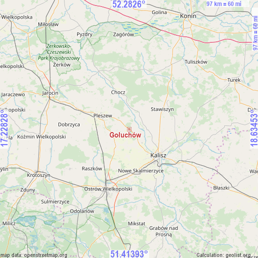
Gołuchów GPS coordinates[2]
51° 51' 1.296" North, 17° 55' 53.04" East
| Map corner | latitude | longitude |
|---|---|---|
| Upper-left | 52.2826°, | 17.22828° |
| Center: | 51.85036°, | 17.9314° |
| Lower-right: | 51.41393°, | 18.63453° |
| Map W x H: | 96.6×96.6 km | = 60×60mi |
| max Lat: | 54.83135° ⇑37.3% North |
| Gołuchów: | 51.85036° |
| min Lat: | ⇓62.7% South 49.21328° |
| min Long | Gołuchów | max Long |
| 14.20249° | 17.9314° | 24.03723° |
| W 24.1%⇐ | ⇒75.9% E |
Elevation
Elevation of Gołuchów is 113 m = 371 ft, and this is 78.4 m = 257 ft below average elevation for this country.
| Max E: |
974 m = 3196 ft | 74% |
| Avg. | 191.4 m = 628 ft | |
| Gołuchów | 113 m = 371 ft | |
Min E: |
-3 m = -10 ft | 26% |
See also: Poland elevation on elevation.city.
Geographical zone
Gołuchów is located in North temperate zone (between Tropic of Cancer and the Arctic Circle). Distance of this North polar circle is 1636 km =1016.6 mi to North.| Distance of | km | miles | from Gołuchów |
|---|---|---|---|
| North Pole | 4241.8 | 2635.7 | to North |
| Arctic Circle | 1636 | 1016.6 | to North |
| Tropic Cancer | 3159.3 | 1963.1 | to South |
| Equator | 5765.2 | 3582.3 | to South |


Nearby cities:
15 places around Gołuchów: (largest is in red/bold)
• Blizanów
8 km =5 mi,  42°
42°
• Broniszewice
15.2 km =9.4 mi,  328°
328°
• Chocz
14.6 km =9.1 mi,  343°
343°
• Czermin
16.7 km =10.4 mi,  311°
311°
• Dębe
18.8 km =11.7 mi,  107°
107°
• Kalisz
14.8 km =9.2 mi,  132°
132°
• Korytnica
17.6 km =10.9 mi,  239°
239°
• Moszczanka
19.8 km =12.3 mi,  222°
222°
• Nowe Skalmierzyce
16.1 km =10 mi,  164°
164°
• Pleszew
11.2 km =7 mi,  297°
297°
• Skalmierzyce
16.8 km =10.4 mi,  172°
172°
• Sobótka
9.3 km =5.8 mi,  212°
212°
• Sośnica
17.3 km =10.7 mi,  274°
274°
• Stawiszyn
14.5 km =9 mi,  58°
58°
• Żelazków
16.7 km =10.4 mi,  88°
88°
Sources, notices
• [Note1] Compared only with cities in Poland existing in our database
• [Src1] Map data: © OpenStreetMap contributors (CC-BY-SA)
• [Src2] Other city data from geonames.org with taken over terms of usage.
• [Src3] Geographical zone / Annual Mean Temperature by Robert A. Rohde @ Wikipedia
