Kalisz geodata
Kalisz (Greater Poland) is a seat of a third-order administrative division; located in Poland in Europe/Warsaw (GMT+2) time zone. With population of 108,759 people, there are 43 cities with bigger population in this country. Compared to other cities in Poland, 61.2% of cities are located further ↓South; 74.3% of cities are located further →East and 75.8% of cities have higher elevation than Kalisz. Note1


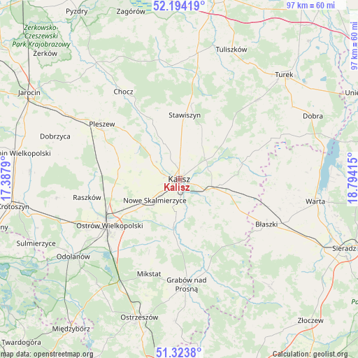
Kalisz GPS coordinates[2]
51° 45' 39.924" North, 18° 5' 27.672" East
| Map corner | latitude | longitude |
|---|---|---|
| Upper-left | 52.19419°, | 17.3879° |
| Center: | 51.76109°, | 18.09102° |
| Lower-right: | 51.3238°, | 18.79415° |
| Map W x H: | 96.8×96.8 km | = 60.1×60.1mi |
| max Lat: | 54.83135° ⇑38.8% North |
| Kalisz: | 51.76109° |
| min Lat: | ⇓61.2% South 49.21328° |
| min Long | Kalisz | max Long |
| 14.20249° | 18.09102° | 24.03723° |
| W 25.7%⇐ | ⇒74.3% E |
Elevation
Elevation of Kalisz is 109 m = 358 ft, and this is 82.4 m = 270 ft below average elevation for this country.
| Max E: |
974 m = 3196 ft | 75.8% |
| Avg. | 191.4 m = 628 ft | |
| Kalisz | 109 m = 358 ft | |
Min E: |
-3 m = -10 ft | 24.2% |
See also: Kalisz elevation on elevation.city.
Geographical zone
Kalisz is located in North temperate zone (between Tropic of Cancer and the Arctic Circle). Distance of this North polar circle is 1645.9 km =1022.7 mi to North.| Distance of | km | miles | from Kalisz |
|---|---|---|---|
| North Pole | 4251.8 | 2641.9 | to North |
| Arctic Circle | 1645.9 | 1022.7 | to North |
| Tropic Cancer | 3149.4 | 1956.9 | to South |
| Equator | 5755.3 | 3576.2 | to South |


Nearby cities:
15 places around Kalisz: (largest is in red/bold)
• Blizanów
16.8 km =10.4 mi,  340°
340°
• Dębe
8.2 km =5.1 mi,  58°
58°
• Godziesze Wielkie
14.1 km =8.8 mi,  156°
156°
• Gołuchów
14.8 km =9.2 mi,  312°
312°
• Kościelec
18.4 km =11.4 mi,  27°
27°
• Koźminek
17.6 km =10.9 mi,  76°
76°
• Nowe Skalmierzyce
8.8 km =5.5 mi,  230°
230°
• Opatówek
9 km =5.6 mi,  105°
105°
• Psary
12.8 km =8 mi,  205°
205°
• Sieroszewice
16.4 km =10.2 mi, 210°
• Skalmierzyce
11 km =6.8 mi, 232°
• Sobótka
16.1 km =10 mi,  277°
277°
• Stawiszyn
17.5 km =10.9 mi,  4°
4°
• Szczytniki
18.4 km =11.4 mi,  115°
115°
• Żelazków
11.8 km =7.3 mi, 28°
Sources, notices
• [Note1] Compared only with cities in Poland existing in our database
• [Src1] Map data: © OpenStreetMap contributors (CC-BY-SA)
• [Src2] Other city data from geonames.org with taken over terms of usage.
• [Src3] Geographical zone / Annual Mean Temperature by Robert A. Rohde @ Wikipedia
