Blizanów geodata
Blizanów (Greater Poland) is a seat of a third-order administrative division; located in Poland in Europe/Warsaw (GMT+2) time zone. With population of 483 people, there are 3547 cities with bigger population in this country. Compared to other cities in Poland, 63.7% of cities are located further ↓South; 75.1% of cities are located further →East and 74% of cities have higher elevation than Blizanów. Note1


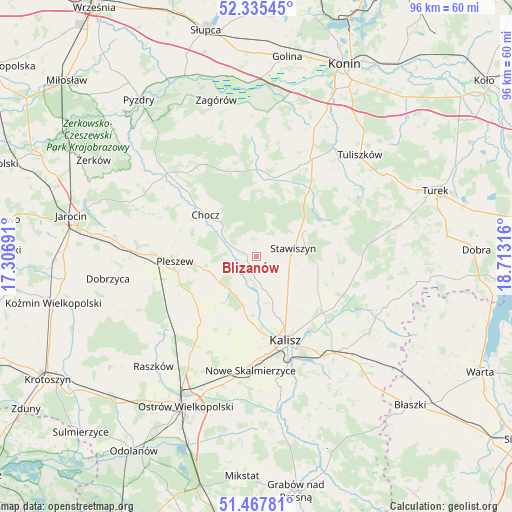
Blizanów GPS coordinates[2]
51° 54' 13.392" North, 18° 0' 36.108" East
| Map corner | latitude | longitude |
|---|---|---|
| Upper-left | 52.33545°, | 17.30691° |
| Center: | 51.90372°, | 18.01003° |
| Lower-right: | 51.46781°, | 18.71316° |
| Map W x H: | 96.5×96.5 km | = 60×60mi |
| max Lat: | 54.83135° ⇑36.3% North |
| Blizanów: | 51.90372° |
| min Lat: | ⇓63.7% South 49.21328° |
| min Long | Blizanów | max Long |
| 14.20249° | 18.01003° | 24.03723° |
| W 24.9%⇐ | ⇒75.1% E |
Elevation
Elevation of Blizanów is 113 m = 371 ft, and this is 78.4 m = 257 ft below average elevation for this country.
| Max E: |
974 m = 3196 ft | 74% |
| Avg. | 191.4 m = 628 ft | |
| Blizanów | 113 m = 371 ft | |
Min E: |
-3 m = -10 ft | 26% |
See also: Poland elevation on elevation.city.
Geographical zone
Blizanów is located in North temperate zone (between Tropic of Cancer and the Arctic Circle). Distance of this North polar circle is 1630 km =1012.8 mi to North.| Distance of | km | miles | from Blizanów |
|---|---|---|---|
| North Pole | 4235.9 | 2632.1 | to North |
| Arctic Circle | 1630 | 1012.8 | to North |
| Tropic Cancer | 3165.2 | 1966.8 | to South |
| Equator | 5771.2 | 3586.1 | to South |


Nearby cities:
15 places around Blizanów: (largest is in red/bold)
• Broniszewice
15 km =9.3 mi,  297°
297°
• Chocz
12.6 km =7.8 mi,  310°
310°
• Czermin
18.6 km =11.6 mi,  286°
286°
• Dębe
17.1 km =10.6 mi,  132°
132°
• Gizałki
22.6 km =14 mi, 313°
• Gołuchów
8 km =5 mi,  222°
222°
• Grodziec
15.4 km =9.6 mi,  12°
12°
• Kalisz
16.8 km =10.4 mi,  160°
160°
• Kościelec
14 km =8.7 mi,  88°
88°
• Nowe Skalmierzyce
21.5 km =13.4 mi,  183°
183°
• Pleszew
15.4 km =9.6 mi,  266°
266°
• Rychwał
21.5 km =13.4 mi,  29°
29°
• Sobótka
17.2 km =10.7 mi, 216°
• Stawiszyn
7.1 km =4.4 mi,  77°
77°
• Żelazków
12.5 km =7.8 mi,  116°
116°
Sources, notices
• [Note1] Compared only with cities in Poland existing in our database
• [Src1] Map data: © OpenStreetMap contributors (CC-BY-SA)
• [Src2] Other city data from geonames.org with taken over terms of usage.
• [Src3] Geographical zone / Annual Mean Temperature by Robert A. Rohde @ Wikipedia
