Grabowo Królewskie geodata
Grabowo Królewskie (Greater Poland) is a populated place; located in Poland in Europe/Warsaw (GMT+2) time zone. With population of 627 people, there are 3215 cities with bigger population in this country. Compared to other cities in Poland, 71% of cities are located further ↓South; 79% of cities are located further →East and 81.8% of cities have higher elevation than Grabowo Królewskie. Note1


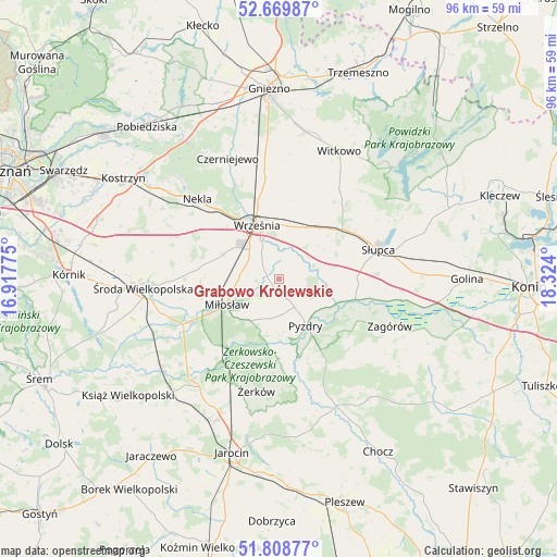
Grabowo Królewskie GPS coordinates[2]
52° 14' 29.076" North, 17° 37' 15.132" East
| Map corner | latitude | longitude |
|---|---|---|
| Upper-left | 52.66987°, | 16.91775° |
| Center: | 52.24141°, | 17.62087° |
| Lower-right: | 51.80877°, | 18.324° |
| Map W x H: | 95.7×95.7 km | = 59.5×59.5mi |
| max Lat: | 54.83135° ⇑29% North |
| Grabowo Królewskie: | 52.24141° |
| min Lat: | ⇓71% South 49.21328° |
| min Long | Grabowo Królew | max Long |
| 14.20249° | 17.62087° | 24.03723° |
| W 21%⇐ | ⇒79% E |
Elevation
Elevation of Grabowo Królewskie is 96 m = 315 ft, and this is 95.4 m = 313 ft below average elevation for this country.
| Max E: |
974 m = 3196 ft | 81.8% |
| Avg. | 191.4 m = 628 ft | |
| Grabowo Królewskie | 96 m = 315 ft | |
Min E: |
-3 m = -10 ft | 18.2% |
See also: Poland elevation on elevation.city.
Geographical zone
Grabowo Królewskie is located in North temperate zone (between Tropic of Cancer and the Arctic Circle). Distance of this North polar circle is 1592.5 km =989.5 mi to North.| Distance of | km | miles | from Grabowo Królewskie |
|---|---|---|---|
| North Pole | 4198.4 | 2608.8 | to North |
| Arctic Circle | 1592.5 | 989.5 | to North |
| Tropic Cancer | 3202.8 | 1990.1 | to South |
| Equator | 5808.7 | 3609.4 | to South |


Nearby cities:
15 places around Grabowo Królewskie: (largest is in red/bold)
• Dominowo
18.8 km =11.7 mi,  287°
287°
• Kołaczkowo
2.7 km =1.7 mi,  175°
175°
• Lisewo
18.3 km =11.4 mi,  164°
164°
• Lądek
21.4 km =13.3 mi,  99°
99°
• Miłosław
9.9 km =6.2 mi,  244°
244°
• Nekla
19.7 km =12.2 mi,  314°
314°
• Nowe Miasto nad Wartą
22.1 km =13.7 mi,  220°
220°
• Pyzdry
9.2 km =5.7 mi,  149°
149°
• Sokolniki
6 km =3.7 mi,  78°
78°
• Strzałkowo
15.3 km =9.5 mi,  61°
61°
• Słupca
17.8 km =11.1 mi,  73°
73°
• Tomice
21 km =13 mi, 157°
• Września
10 km =6.2 mi,  337°
337°
• Zagórów
20.4 km =12.7 mi,  113°
113°
• Żerków
19.6 km =12.2 mi,  191°
191°
Sources, notices
• [Note1] Compared only with cities in Poland existing in our database
• [Src1] Map data: © OpenStreetMap contributors (CC-BY-SA)
• [Src2] Other city data from geonames.org with taken over terms of usage.
• [Src3] Geographical zone / Annual Mean Temperature by Robert A. Rohde @ Wikipedia
