Jabłonna geodata
Jabłonna (Greater Poland) is a populated place; located in Poland in Europe/Warsaw (GMT+2) time zone. With population of 1,001 people, there are 2458 cities with bigger population in this country. Compared to other cities in Poland, 70.3% of cities are located further ↓South; 91.3% of cities are located further →East and 87.8% of cities have higher elevation than Jabłonna. Note1


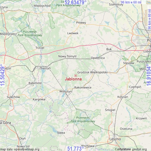
Jabłonna GPS coordinates[2]
52° 12' 21.528" North, 16° 12' 26.676" East
| Map corner | latitude | longitude |
|---|---|---|
| Upper-left | 52.63479°, | 15.50429° |
| Center: | 52.20598°, | 16.20741° |
| Lower-right: | 51.773°, | 16.91054° |
| Map W x H: | 95.8×95.8 km | = 59.5×59.5mi |
| max Lat: | 54.83135° ⇑29.7% North |
| Jabłonna: | 52.20598° |
| min Lat: | ⇓70.3% South 49.21328° |
| min Long | Jabłonna | max Long |
| 14.20249° | 16.20741° | 24.03723° |
| W 8.7%⇐ | ⇒91.3% E |
Elevation
Elevation of Jabłonna is 82 m = 269 ft, and this is 109.4 m = 359 ft below average elevation for this country.
| Max E: |
974 m = 3196 ft | 87.8% |
| Avg. | 191.4 m = 628 ft | |
| Jabłonna | 82 m = 269 ft | |
Min E: |
-3 m = -10 ft | 12.2% |
See also: Poland elevation on elevation.city.
Geographical zone
Jabłonna is located in North temperate zone (between Tropic of Cancer and the Arctic Circle). Distance of this North polar circle is 1596.4 km =992 mi to North.| Distance of | km | miles | from Jabłonna |
|---|---|---|---|
| North Pole | 4202.3 | 2611.2 | to North |
| Arctic Circle | 1596.4 | 992 | to North |
| Tropic Cancer | 3198.8 | 1987.6 | to South |
| Equator | 5804.8 | 3606.9 | to South |


Nearby cities:
15 places around Jabłonna: (largest is in red/bold)
• Babimost
26.3 km =16.3 mi,  259°
259°
• Granowo
22 km =13.7 mi,  85°
85°
• Grodzisk Wielkopolski
11 km =6.8 mi,  77°
77°
• Kamieniec
17.9 km =11.1 mi,  104°
104°
• Kuślin
19 km =11.8 mi,  22°
22°
• Miedzichowo
25.3 km =15.7 mi,  318°
318°
• Nowy Tomyśl
13.7 km =8.5 mi,  336°
336°
• Opalenica
18.1 km =11.2 mi,  50°
50°
• Pakosław
25.6 km =15.9 mi,  6°
6°
• Przemęt
22.9 km =14.2 mi,  163°
163°
• Rakoniewice
8.7 km =5.4 mi,  148°
148°
• Siedlec
15.9 km =9.9 mi,  241°
241°
• Wielichowo
14.1 km =8.8 mi,  135°
135°
• Wolsztyn
11.8 km =7.3 mi,  211°
211°
• Zbąszyń
19.9 km =12.4 mi,  284°
284°
Sources, notices
• [Note1] Compared only with cities in Poland existing in our database
• [Src1] Map data: © OpenStreetMap contributors (CC-BY-SA)
• [Src2] Other city data from geonames.org with taken over terms of usage.
• [Src3] Geographical zone / Annual Mean Temperature by Robert A. Rohde @ Wikipedia
