Wilków geodata
Wilków (Lower Silesia) is a populated place; located in Poland in Europe/Warsaw (GMT+2) time zone. With population of 2,000 people, there are 1469 cities with bigger population in this country. Compared to other cities in Poland, 52.9% of cities are located further ↑North; 92.9% of cities are located further →East and 81.7% of cities have lower elevation than Wilków. Note1


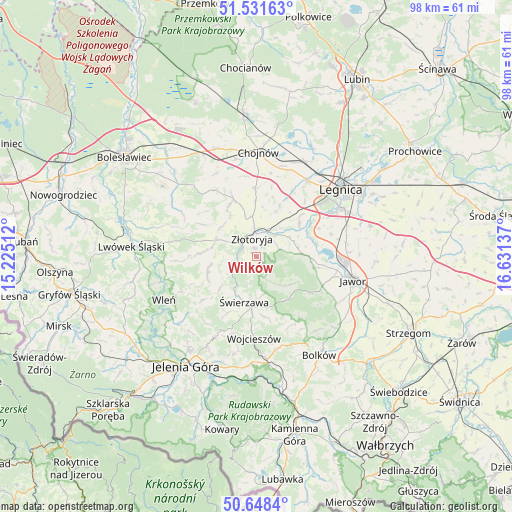
Wilków GPS coordinates[2]
51° 5' 31.632" North, 15° 55' 41.664" East
| Map corner | latitude | longitude |
|---|---|---|
| Upper-left | 51.53163°, | 15.22512° |
| Center: | 51.09212°, | 15.92824° |
| Lower-right: | 50.6484°, | 16.63137° |
| Map W x H: | 98.2×98.2 km | = 61×61mi |
| max Lat: | 54.83135° ⇑52.9% North |
| Wilków: | 51.09212° |
| min Lat: | ⇓47.1% South 49.21328° |
| min Long | Wilków | max Long |
| 14.20249° | 15.92824° | 24.03723° |
| W 7.1%⇐ | ⇒92.9% E |
Elevation
Elevation of Wilków is 274 m = 899 ft, and this is 82.6 m = 271 ft above average elevation for this country.
| Max E: |
974 m = 3196 ft | 18.3% |
| Wilków | 274 m 899 ft | |
| Avg. | 191.4 m = 628 ft | |
Min E: |
-3 m = -10 ft | 81.7% |
See also: Poland elevation on elevation.city.
Geographical zone
Wilków is located in North temperate zone (between Tropic of Cancer and the Arctic Circle). Distance of this North polar circle is 1720.3 km =1068.9 mi to North.| Distance of | km | miles | from Wilków |
|---|---|---|---|
| North Pole | 4326.2 | 2688.2 | to North |
| Arctic Circle | 1720.3 | 1068.9 | to North |
| Tropic Cancer | 3075 | 1910.7 | to South |
| Equator | 5680.9 | 3529.9 | to South |


Nearby cities:
15 places around Wilków: (largest is in red/bold)
• Chojnów
20.2 km =12.6 mi,  1°
1°
• Jawor
19.1 km =11.9 mi,  103°
103°
• Krotoszyce
10.2 km =6.3 mi,  53°
53°
• Legnica
20.9 km =13 mi, 51°
• Miłkowice
20.8 km =12.9 mi,  28°
28°
• Męcinka
12 km =7.5 mi, 99°
• Olszanica
15.6 km =9.7 mi,  325°
325°
• Paszowice
18.1 km =11.2 mi,  119°
119°
• Pielgrzymka
8.4 km =5.2 mi,  288°
288°
• Sędziszowa
8.2 km =5.1 mi,  206°
206°
• Wleń
19.6 km =12.2 mi,  244°
244°
• Wojcieszów
15.6 km =9.7 mi,  181°
181°
• Zagrodno
11.9 km =7.4 mi,  338°
338°
• Złotoryja
3.9 km =2.4 mi,  351°
351°
• Świerzawa
9 km =5.6 mi,  194°
194°
Sources, notices
• [Note1] Compared only with cities in Poland existing in our database
• [Src1] Map data: © OpenStreetMap contributors (CC-BY-SA)
• [Src2] Other city data from geonames.org with taken over terms of usage.
• [Src3] Geographical zone / Annual Mean Temperature by Robert A. Rohde @ Wikipedia
