Przykona geodata
Przykona (Greater Poland) is a seat of a third-order administrative division; located in Poland in Europe/Warsaw (GMT+2) time zone. With population of 520 people, there are 3482 cities with bigger population in this country. Compared to other cities in Poland, 65.4% of cities are located further ↓South; 66.4% of cities are located further →East and 75% of cities have higher elevation than Przykona. Note1


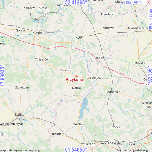
Przykona GPS coordinates[2]
51° 58' 54.156" North, 18° 36' 44.892" East
| Map corner | latitude | longitude |
|---|---|---|
| Upper-left | 52.41268°, | 17.90935° |
| Center: | 51.98171°, | 18.61247° |
| Lower-right: | 51.54655°, | 19.3156° |
| Map W x H: | 96.3×96.3 km | = 59.8×59.8mi |
| max Lat: | 54.83135° ⇑34.6% North |
| Przykona: | 51.98171° |
| min Lat: | ⇓65.4% South 49.21328° |
| min Long | Przykona | max Long |
| 14.20249° | 18.61247° | 24.03723° |
| W 33.6%⇐ | ⇒66.4% E |
Elevation
Elevation of Przykona is 111 m = 364 ft, and this is 80.4 m = 264 ft below average elevation for this country.
| Max E: |
974 m = 3196 ft | 75% |
| Avg. | 191.4 m = 628 ft | |
| Przykona | 111 m = 364 ft | |
Min E: |
-3 m = -10 ft | 25% |
See also: Poland elevation on elevation.city.
Geographical zone
Przykona is located in North temperate zone (between Tropic of Cancer and the Arctic Circle). Distance of this North polar circle is 1621.3 km =1007.4 mi to North.| Distance of | km | miles | from Przykona |
|---|---|---|---|
| North Pole | 4227.2 | 2626.7 | to North |
| Arctic Circle | 1621.3 | 1007.4 | to North |
| Tropic Cancer | 3173.9 | 1972.2 | to South |
| Equator | 5779.8 | 3591.4 | to South |


Nearby cities:
15 places around Przykona: (largest is in red/bold)
• Brudzew
13.1 km =8.1 mi,  357°
357°
• Dobra
7.2 km =4.5 mi,  178°
178°
• Dąbie
18.5 km =11.5 mi,  50°
50°
• Goszczanów
22.4 km =13.9 mi,  199°
199°
• Kawęczyn
9.8 km =6.1 mi,  214°
214°
• Kościelec
21.6 km =13.4 mi,  352°
352°
• Lisków
22.1 km =13.7 mi,  221°
221°
• Malanów
15.5 km =9.6 mi,  258°
258°
• Pęczniew
21.2 km =13.2 mi,  158°
158°
• Russocice
17.1 km =10.6 mi,  328°
328°
• Tarnowa
20.7 km =12.9 mi,  307°
307°
• Turek
8.5 km =5.3 mi,  296°
296°
• Uniejów
12.4 km =7.7 mi,  93°
93°
• Władysławów
16.4 km =10.2 mi, 325°
• Świnice Warckie
21.9 km =13.6 mi,  72°
72°
Sources, notices
• [Note1] Compared only with cities in Poland existing in our database
• [Src1] Map data: © OpenStreetMap contributors (CC-BY-SA)
• [Src2] Other city data from geonames.org with taken over terms of usage.
• [Src3] Geographical zone / Annual Mean Temperature by Robert A. Rohde @ Wikipedia
