Czaplinek geodata
Czaplinek (West Pomerania) is a populated place; located in Poland in Europe/Warsaw (GMT+2) time zone. With population of 6,933 people, there are 543 cities with bigger population in this country. Compared to other cities in Poland, 90.2% of cities are located further ↓South; 91.2% of cities are located further →East and 60.6% of cities have higher elevation than Czaplinek. Note1


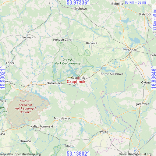
Czaplinek GPS coordinates[2]
53° 33' 27.9" North, 16° 13' 59.988" East
| Map corner | latitude | longitude |
|---|---|---|
| Upper-left | 53.97336°, | 15.53021° |
| Center: | 53.55775°, | 16.23333° |
| Lower-right: | 53.13802°, | 16.93646° |
| Map W x H: | 92.9×92.9 km | = 57.7×57.7mi |
| max Lat: | 54.83135° ⇑9.8% North |
| Czaplinek: | 53.55775° |
| min Lat: | ⇓90.2% South 49.21328° |
| min Long | Czaplinek | max Long |
| 14.20249° | 16.23333° | 24.03723° |
| W 8.8%⇐ | ⇒91.2% E |
Elevation
Elevation of Czaplinek is 145 m = 476 ft, and this is 46.4 m = 152 ft below average elevation for this country.
| Max E: |
974 m = 3196 ft | 60.6% |
| Avg. | 191.4 m = 628 ft | |
| Czaplinek | 145 m = 476 ft | |
Min E: |
-3 m = -10 ft | 39.4% |
See also: Poland elevation on elevation.city.
Geographical zone
Czaplinek is located in North temperate zone (between Tropic of Cancer and the Arctic Circle). Distance of this North polar circle is 1446.1 km =898.6 mi to North.| Distance of | km | miles | from Czaplinek |
|---|---|---|---|
| North Pole | 4052 | 2517.8 | to North |
| Arctic Circle | 1446.1 | 898.6 | to North |
| Tropic Cancer | 3349.1 | 2081 | to South |
| Equator | 5955.1 | 3700.3 | to South |


Nearby cities:
15 places around Czaplinek: (largest is in red/bold)
• Barwice
22.3 km =13.9 mi,  21°
21°
• Borne Sulinowo
20 km =12.4 mi,  83°
83°
• Brzeżno
33.1 km =20.6 mi,  298°
298°
• Drawsko Pomorskie
28.2 km =17.5 mi,  263°
263°
• Grzmiąca
33.8 km =21 mi, 23°
• Kalisz Pomorski
36 km =22.4 mi,  216°
216°
• Mirosławiec
26 km =16.2 mi,  201°
201°
• Połczyn-Zdrój
24.7 km =15.3 mi,  338°
338°
• Sitno
30.6 km =19 mi,  68°
68°
• Sypniewo
26.6 km =16.5 mi,  112°
112°
• Szczecinek
35 km =21.7 mi,  61°
61°
• Wałcz
34.9 km =21.7 mi,  153°
153°
• Wierzchowo
14 km =8.7 mi, 219°
• Złocieniec
14.9 km =9.3 mi, 259°
• Łubowo
10.9 km =6.8 mi, 73°
Sources, notices
• [Note1] Compared only with cities in Poland existing in our database
• [Src1] Map data: © OpenStreetMap contributors (CC-BY-SA)
• [Src2] Other city data from geonames.org with taken over terms of usage.
• [Src3] Geographical zone / Annual Mean Temperature by Robert A. Rohde @ Wikipedia
